1. St Philip’s Marsh – engagement on Supplementary Planning Document
This public engagement focuses on the guidance in a draft Supplementary Planning Document (SPD) which will guide development in St Philip’s Marsh in the future.
This engagement is the next step in preparing the SPD. The draft guidance builds on the early ideas presented and engaged on in Summer 2025 (click here to read the engagement report).
A Supplementary Planning Document (SPD) is a planning document – a tool for planners to help them assess planning applications as they come forward. It sits alongside other planning policy documents such as the Local Plan.
Alongside this period of public engagement and gathering your feedback, further stakeholder engagement and technical analysis on specific issues is taking place to test and better understand some of the key moves outlined.
The emerging SPD sets out a clear framework to guide development and will be one of the tools that will help turn this long-term vision into delivery. The SPD will supplement the Local Plan. While it cannot set new planning policy, it will provide guidance for landowners, investors and developers looking to bring change to the area, and support planning officers when reviewing planning applications to enable coordinated, high-quality and sustainable development.
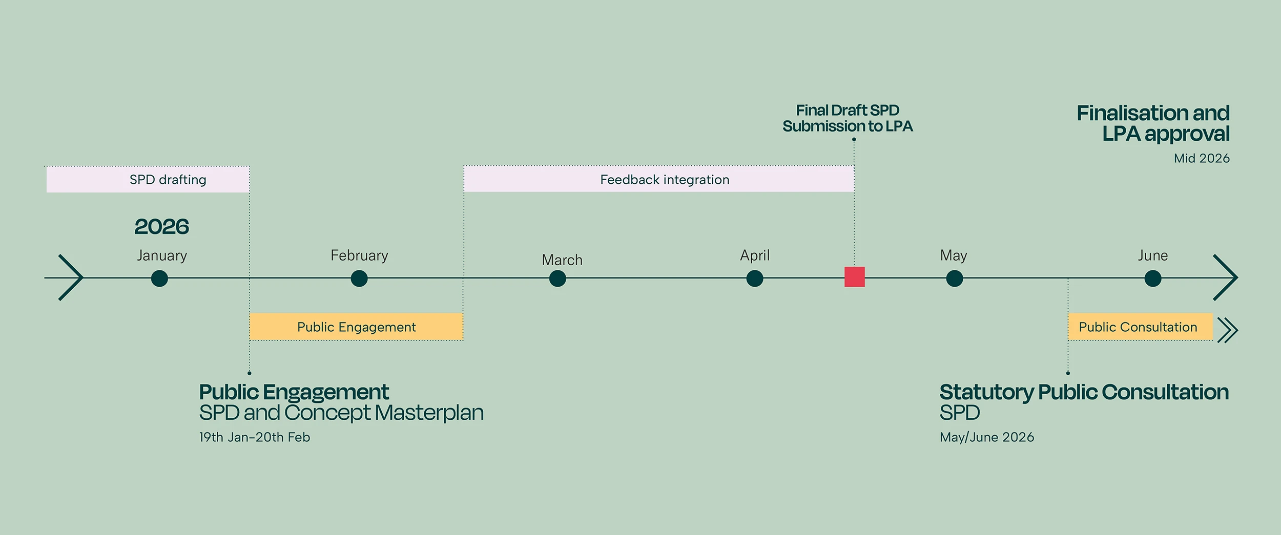
Your feedback and this further work will help us to refine the draft guidance into a final SPD. This will then be submitted to the Local Planning Authority (Bristol City Council), at which point a six-week formal consultation will take place. This will be another opportunity to have your say. If adopted, the SPD will guide future development alongside the Local Plan, helping to ensure delivery remains aligned with the partners’ shared vision. A summary timeline is included below.
The following pages set out the principles under different themes. In each section there is a short summary of the main guidance applicable to that theme. There are then drop-down boxes with extracts from the draft SPD for those who would like to know a bit more detail.
Each section is marked with a reference number (eg SPM 01).
The illustrative masterplan for St Philip’s Marsh, shown on page 10, is indicative only and presented as just one potential outcome of following the principles in the draft SPD. It is for illustrative purposes only.
A survey can be found on the tab at the top (page 12).
- About the engagement
- Project introduction and purpose of SPD
- Objectives for St Philip’s Marsh
- St Philip’s Marsh development framework
- Land uses
- Character areas and heritage
- Blue and green infrastructure
- Height, density, roof treatment, daylight, sunlight and microclimate
- Access and movement
- Illustrative Masterplan
- Infrastructure delivery plan
- Survey
- Glossary
You can read the information and complete the survey online, or alternatively request a paper copy of the information by emailing hello@bristoltemplequarter.com
We are holding the following drop-in events:
Community drop-ins
Wednesday 4 February 2026, 4-7pm
Asda Bedminster, East St, Bristol BS3 4JY
Monday 9 February 2026, 4-7pm
Sainsbury’s Avonmeads, St Philip’s Causeway, Bristol BS4 3BD
Wednesday 11 February 2026, 3-6pm
Tesco Totterdown, 33 Oxford St, Bristol BS3 4RJ
Thursday 19 February 2026, 2.30-6.30pm
Safe ’Ouse, The Dings, Oxford Street, Bristol, BS2 0QR
Visit us at the Bristol Temple Quarter Hub
Bristol Temple Quarter Hub, Unit 1, Temple Gate BS1 6QA
Find us on Google Maps. What 3 words location: strut.potato.pigs
Monday 26 January 2026, 10am-3pm
Monday 2 February 2026, 10am-3pm
Monday 9 February 2026, 10am-3pm
Monday 16 February 2026, 3pm-7pm
What next?
Following this round of engagement the draft SPD will be reviewed and a final version will go out to consultation via the Local Planning Authority (LPA) later in 2026.
St Philip’s Marsh SPD timeline
2. Introduction and background
In 2023, the Bristol Temple Quarter Development Framework presented concept ideas for how St Philip’s Marsh could change in the future. Since then, these ideas have been developed further, taking into account what the city needs, changes that have taken place since the Development Framework was produced, and feedback received through business, stakeholder and community engagement.
We have also developed a “Vision for Place” for the kind of place we want to create at Temple Quarter, where people will want to live, work and spend time (you can find out more on page 3). This was shaped by public feedback, and this vision has also shaped emerging thinking about St Philip’s Marsh and subsequently the draft SPD.
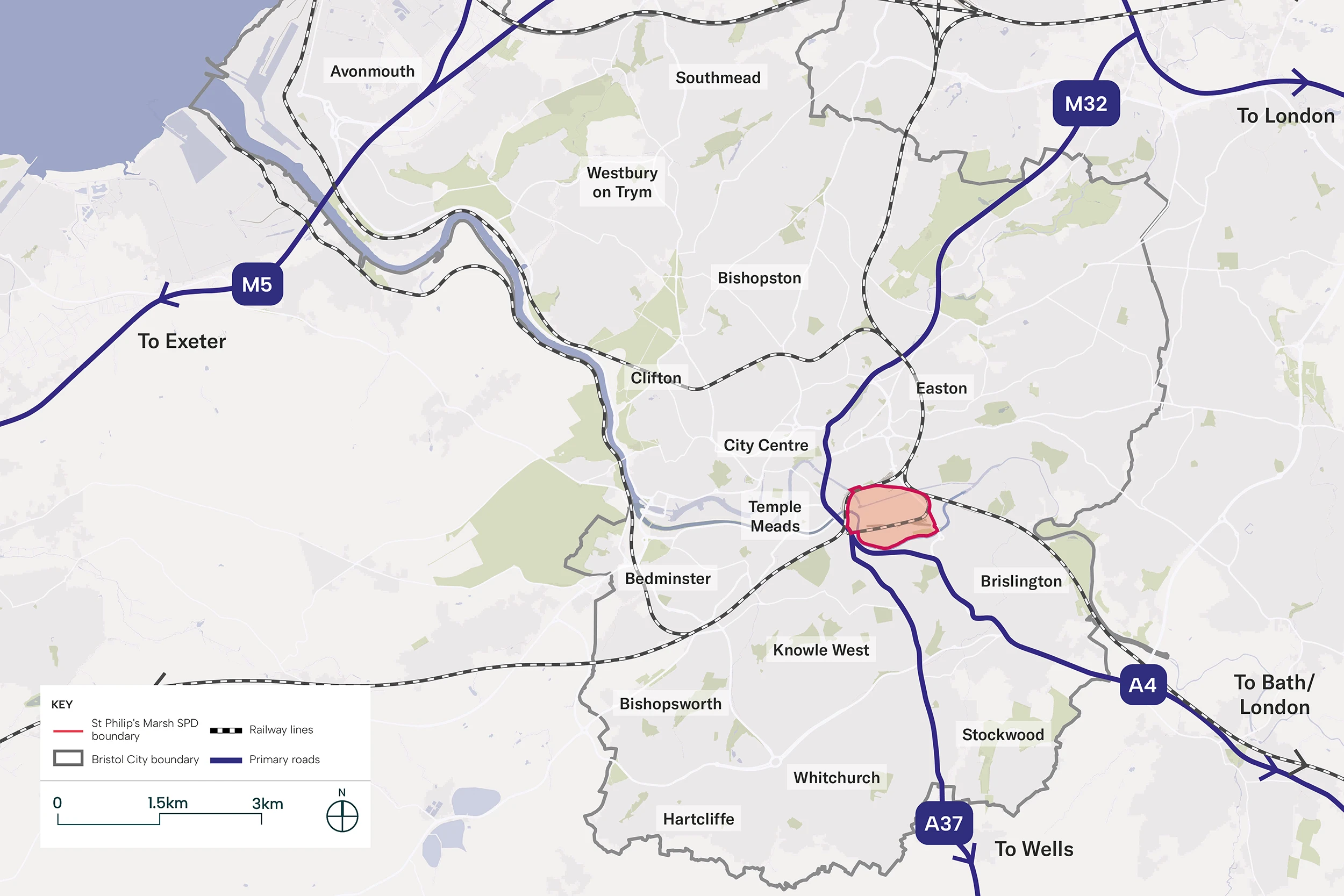
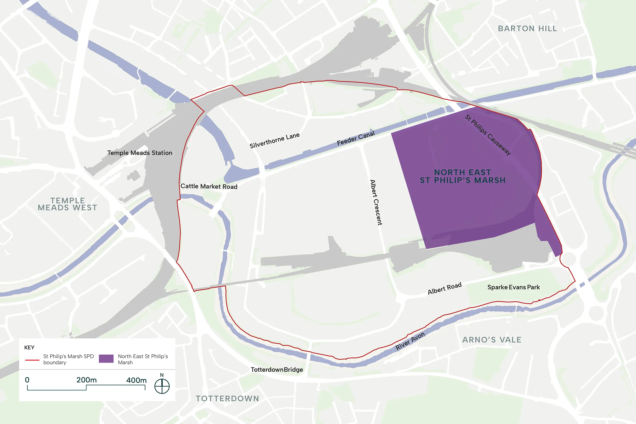
The map below shows where St Philip’s Marsh and the boundary of the Supplementary Planning Document (SPD) is in relation to the wider city.
What is a Supplementary Planning Document (SPD)?
- It is a tool to assist in the assessment of planning applications within the SPD boundary.
- It helps applicants understand what development is supported and helps consultees and Local Planning Authority assess planning applications.
- It is not a standalone document and should be read in conjunction with other national and local planning policy.
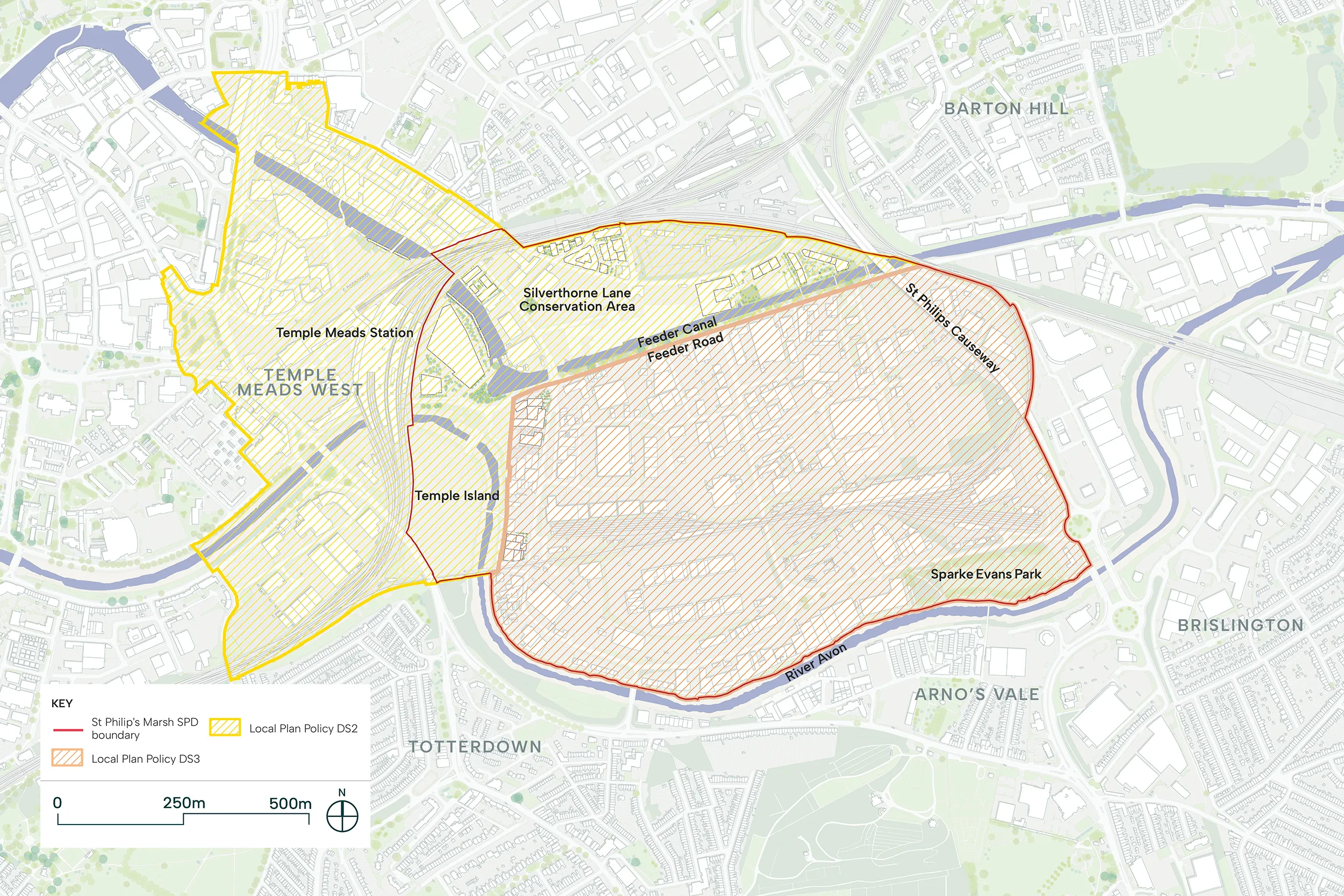
The map below shows the Bristol Temple Quarter regeneration area including the SPD boundary and how this relates to planning principles in the Bristol Local Plan (policies DS2 and DS3).
What will the SPD address?
- Identify areas where residential, employment and mixed-use development will be supported.
- Identify areas which would be more suitable for potential taller buildings/areas of height.
- Provide additional confidence that appropriate densities can deliver suitable development to meet delivery assumptions.
- Identify where safeguarded transport infrastructure and utility infrastructure are located.
- Identify scale and potential locations for community facilities.
- Identify areas for pedestrian route improvements at the strategic level.
- Propose public realm improvement locations, extent and examples of appropriate interventions.
- Identify opportunities for open space provision.
- Set out an approach to what appropriate car parking provision in this area would be, via a high level car parking strategy.
- Identify appropriate areas for student accommodation (although noting the threshold is subject to ongoing examination).
- Potential responses and interfaces with the Avon Riversides 2100 (formerly Bristol Avon Flood Strategy) alleviation scheme.
- Provide an illustrative example of the area’s overall regeneration vision, to serve as a benchmark for assessing other developments that might conflict with it.
Relationship between principles and illustrative masterplan
The illustrative masterplan shows one possible way St Philip’s Marsh could look in the future. It helps check whether the proposed SPD principles work in practice and whether the overall vision for the area can realistically be delivered. Because the SPD principles are flexible, this masterplan is only an example and not the only way the area could be developed.
3. Objectives for St Philip’s Marsh
The vision for St Philip’s Marsh is to establish a vibrant and inclusive neighbourhood underpinned by robust social, cultural, economic and environmental frameworks. Emphasising Bristol’s diversity, it will provide quality and affordable homes, foster job creation, celebrate culture and revitalise the environment. Combining heritage with sustainable design, it will set a new standard for community-focused development in the city-region.
Bristol’s Unique Spirit
To make this vision a reality, we’ve started with what makes Bristol special: its diverse culture, independent thinking, creative spirit, historic fabric and natural beauty. These qualities must be at the heart of St Philip’s Marsh. Read more about the Vision for Place here: Placemaking – Bristol Temple Quarter
The regeneration will celebrate Bristol’s diverse culture through inclusive places that welcome people of all backgrounds. It will embrace the city’s tradition of independent thinking by supporting innovation, enterprise and businesses of all sizes. Bristol’s creative spirit will be nurtured through spaces for artists, makers and cultural activity. The historic fabric of the site—its industrial heritage, listed structures and waterways—will inform the character of new development and public realm. Bristol’s natural beauty will be enhanced through the celebration of the River Avon, Feeder Canal and a comprehensive network of green spaces.
The Five Guiding Principles
Bristol’s unique spirit has shaped five guiding principles for the neighbourhood:
- Integrated and Connected – Easy, sustainable movement around the area and to wider Bristol
- Inclusive Economic Growth – Benefits and opportunities shared fairly across all communities
- Creative and Vibrant Communities – New homes and inclusive places to live, work and play
- Quality Open Spaces – Public spaces that blend culture and nature
- Brilliant Buildings – Future-proofed buildings with distinct character and heritage connections
Together, these principles will help us deliver four ambitions for St Philip’s Marsh:
- A new mixed-use district in the heart of Bristol
- A unique and inclusive place for learning, working, living and growing
- A place for people
- A climate-resilient neighbourhood
All development proposals will be tested against these ambitions and principles, ensuring they contribute to the wider vision and that the benefits of regeneration are shared by all.
4. St Philip’s Marsh Development framework
The key moves are the main elements that will shape the transformation of St Philip’s Marsh. They are informed by the objectives and guiding principles set out previously, respond to the site’s unique context and constraints, and have been refined through public engagement to reflect community priorities.
These key moves define the essential components that must be delivered to unlock the area’s development potential and guide its evolution in a coordinated and coherent manner. They inform all of the principles in the St Philip’s Marsh Supplementary Planning Document (SPD), and any new development will need to show how it helps deliver them.
The key moves include:
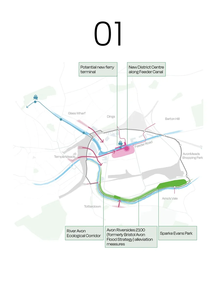
These key moves form the basis for the Framework Plan.
Framework Plan (SPM 24)
- Development coming forward within the SPD area will be required to have regard to the requirements set out in the Framework Plan, including key pedestrian and vehicle routes, and blue and green infrastructure.
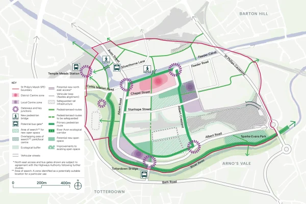
Further information about Framework Plan (SPM 24)
Development coming forward within the SPD area must have regard to the requirements set out in the Framework Plan below, including the land use, movement, and blue and green infrastructure strategies.
The Framework Plan must be read alongside character area guidance (in page 6 of this Digital Hub). Development which conflicts with the Framework Plan without suitable justification of non-compliance will be refused as this will prejudice the comprehensive regeneration of the area.
The Illustrative Masterplan (in page 10 of this Digital Hub) sets out one way in which the Framework Plan can be delivered. Each planning application coming forward within the SPD area should consider the Illustrative Masterplan, should demonstrate how comprehensive development will not be fettered by the proposals coming forward, and how the future development context has been considered.

The Framework Plan establishes the spatial structure for St Philip’s Marsh, setting out the essential components that will guide the comprehensive regeneration of the area.
It defines the arrangement of movement networks, local centres, open spaces and ecological corridors that together create the foundation for a complete neighbourhood. This also ensures that a coordinated approach to development is taken, ensuring that individual proposals contribute to the delivery of a coherent and legible neighbourhood.
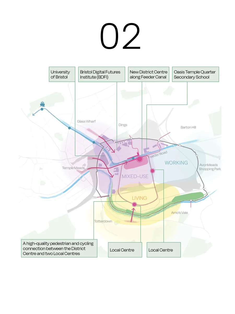
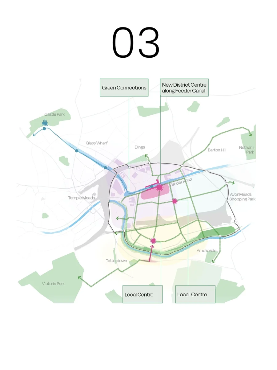
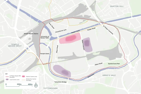
District and Local Centres
The district centre is located along Feeder Canal, establishing the waterfront as St Philip’s Marsh’s primary destination. A new pedestrian bridge aligned with the district centre will improve connectivity across the canal and create a focal point for activity. The centre will accommodate a mix of retail, leisure, community, and commercial uses serving both residents and the Bristol area.
Local centres are positioned along two other main connections Albert Road and Albert Crescent, ensuring all residents have convenient access to everyday services and amenities within walking distance.
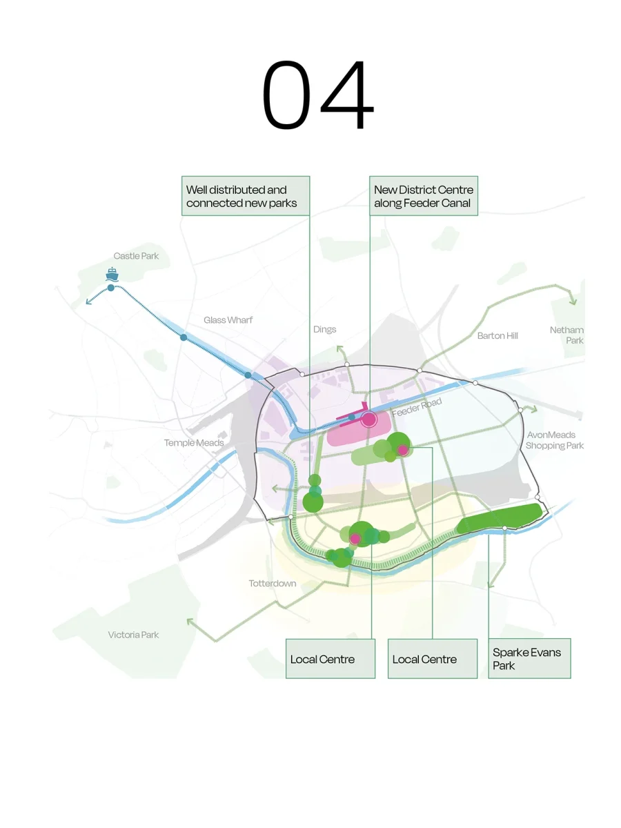
Open Spaces and Parks
The Framework Plan identifies key neighbourhood open spaces. A new park in the North West St Philip’s Marsh character area will provide space for play and relaxation for residents and workers in the northern clusters. It will be framed by a mix of uses, with residential and community functions encouraged around it, and will be connected strategically via Albert Crescent.
Another park in the South St Philip’s Marsh character area will offer space for recreation, play, gathering, and opportunities for biodiversity. It will bridge the level change between the Fruit Market Neighbourhood and the Riverside Community, integrating the two areas and providing a green connection between them.
The enhancement of Sparke Evans Park will complement these new spaces.
Ecological Corridor
An ecological corridor is established along the River Avon, creating a continuous green edge along the site’s southern boundary. This enhances biodiversity, supports habitat connectivity, and maximises the river’s ecological potential as a blue asset. The corridor integrates flood defence infrastructure and provides an attractive setting for active travel routes along the waterfront.
Movement and Connectivity
A network of pedestrianised routes will improve connectivity across the marsh, promoting active mobility, and addressing existing barriers to movement. Where these routes are crossed by vehicular traffic, pedestrian safety and comfort will be prioritised through clear, legible crossings (crossing will be required). The partial pedestrianisation of Feeder Road, Albert Crescent, the transformation of Victoria Street into a linear park, and a new active travel route parallel to Albert Road will create an active travel loop that connects all clusters and key areas of St Philip’s Marsh.
A new north–south route between Albert Road and Albert Crescent is safeguarded to connect Totterdown Bridge with the Feeder Canal district centre if the western section depot is ever redeveloped.
Enhancements to the Cole Road underpass will strengthen eastbound pedestrian connections beyond the site boundary. New bridges across Feeder Canal and the Floating Harbour, north of Totterdown Basin, will improve access to Silverthorne Lane and new eastern entrance of Bristol Temple Meads.
Albert Road, Chapel Street, and Stanhope Street will be designed for slower movement while accommodating access and servicing of developments in the Marsh. Potential bus gates at Avon Street and Totterdown Bridge will limit through-traffic, reducing unnecessary vehicle journeys while maintaining public transport access to the area.
A new access to the North East cluster is required to minimise impacts on future residents. Residential amenity should be ensured and preserved in the interim before the upgraded access delivery.
Flexibility Within the Framework
The Framework Plan identifies routes that are required but where alignment is flexible, allowing development proposals to respond to site-specific conditions whilst delivering the necessary connections.
5. Land uses
The principles related to land use indicate which areas are suitable for housing, employment, mixed-use, a new primary school, and District or Local Centres. They also explain what is expected for each type of development.
Employment (SPM 02)
- Employment and mixed-use development will be supported and steered towards in the North East and North West areas of St Philip’s Marsh.
- A minimum of 40,000sqm of office floorspace and a minimum of 110,000sqm of industrial floorspace will be provided in St Philip’s Marsh.
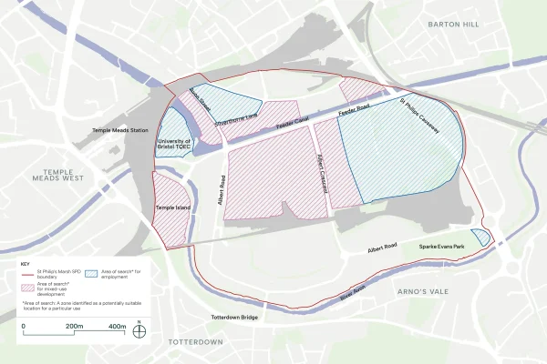
Further information about Employment (SPM 02)
Employment-led and mixed-use development will be supported and steered towards appropriate locations in the north part of St Philip’s Marsh, as shown in diagram below.
St Philip’s Marsh will deliver a minimum of 40,000sqm of new high quality office (Class E(g(i))) floorspace and a minimum of 110,000sqm of new industrial (Class E(g)(ii), E(g)(iii), B2 and B8 and other employment-generating uses) within the Policy DS3 area of the SPD boundary. A proportion of 100,00sqm of office floorspace (Class E(g)(i)) will be delivered in the Policy DS2 area of the SPD boundary.
Other employment land uses will be supported on their own merits.
In mixed-use areas, primarily the North West Character Area, employment uses will be supported on the lower floors with residential on upper floors, subject to impact on residential amenity. Residential uses will be supported in these locations where they would not be detrimental to achieving the employment-led vision for this location, and are in line with relevant policies and guidance.
Employment uses proposed adjacent to existing or proposed housing must consider potential impact on residential amenity and avoid adverse impact.
St Philip’s Marsh will be expected to deliver a range of new employment types to support the focus of office, innovation, research and industrial sectors.
The design of employment development should be high quality and sustainable, and must be in keeping with the relevant character area guidance (set out in page 6 of this Digital Hub).
It is expected that the number of jobs within St Philip’s Marsh will increase. Bristol City Council will monitor the number of jobs delivered against the Local Plan (2026) requirements during the determination of applications.
Background information/ Guidance
St Philip’s Marsh has long been a place of industry and enterprise, making a significant contribution to Bristol’s economy. The regeneration presents an opportunity to build upon this legacy, transitioning from a predominantly industrial area to a diverse employment destination.
The proximity to the university campus creates the potential for an economic ecosystem where research, innovation and commercial enterprise can reinforce one another. Businesses of all sizes—from start-ups seeking their first workspace to established companies requiring high-specification offices—will benefit from access to talent and knowledge exchange, while graduates and researchers will find opportunities to establish and grow locally.
The Bristol Local Plan (2026) under Policy E3 supports offices in Bristol Temple Quarter (Policy DS2) and at appropriate locations in St Philip’s Marsh (Policy DS3). Policy E5 supports industrial and distribution premises along Feeder Road. The delivery of employment floorspace and job numbers will be monitored by BCC.
In the North East cluster, large institutional uses that serve the city and wider region will be supported in addition to the retention and consolidation of industrial uses.
Retaining, intensifying and reimagining industrial activity is key to maintaining the economic diversity that makes the area distinctive and provides employment for a broad range of skills and backgrounds. The Council recognises the value of existing businesses and will support the retention and/or re-consolidation of existing business in the area. Large industrial uses will be supported.
New ways of working require new building typologies. The intensification of industrial uses through stacked formats, hybrid buildings and flexible workspace enable businesses to remain in St Philip’s Marsh as land values change, while making efficient use of a constrained site. These formats also allow employment uses to coexist more comfortably alongside homes, managing the interface between production and residential life. In mixed-use areas, lower floors must be market facing to avoid atomisation or vacancy.
The provision of affordable workspace will be supported in line with Policy E6 of the Bristol Local Plan (2026). The provision of affordable workspace is key to ensuring that small businesses, creative enterprises and community organisations can continue to operate within the area as it changes. Workspace that is accessible and adaptable will support a diverse business community and maintain the entrepreneurial character of the area.
Employment development should be sustainable, demonstrates how it aligns with Bristol’s net zero ambitions.
The benefits of regeneration should also be shared; local residents and existing communities must have the opportunity to access employment and develop skills that enable them to participate in the area’s economic future.
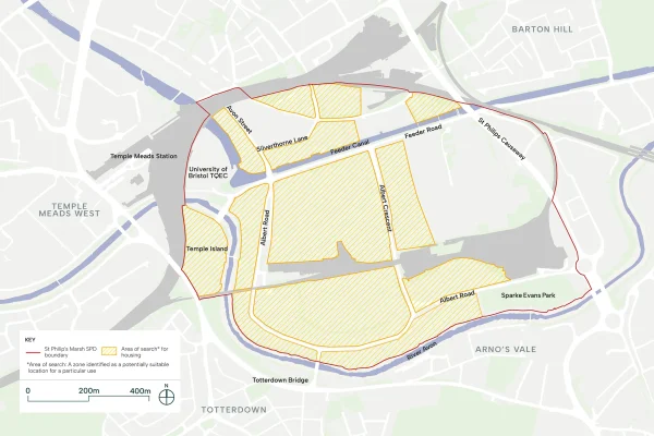
Housing (SPM 03)
- Residential development will be supported in the North West and South areas of St Philip’s Marsh, close to services and transport infrastructure, where it can be delivered while maintaining the quality of the living environment.
- A minimum of 7,000 new homes will be delivered in St Philip’s Marsh.
Further information about Housing (SPM 03)
Residential-led development will be expected to make efficient use of land in appropriate locations and steered towards the areas identified in diagram below.
St Philip’s Marsh will deliver a minimum of 7,000 new homes (Use Class C2 and C3), including affordable housing, within the Policy DS3 area, with a proportion of 3,000 homes delivered in the Policy DS2 area of the SPD boundary.
Other residential land uses, such as co-living, will be supported on their own merits and in line with relevant guidance.
Non-residential uses may be suitable in the locations identified in the diagram below where they will not be detrimental to achieving the residential-led vision in these locations and would accord with all other relevant policies.
Residential development will be supported in locations in proximity to services and transport infrastructure where amenity can be preserved. Larger homes should be located in areas with good access to open spaces, schools and other social infrastructure facilities.
An Affordable Housing Statement must be submitted with all major residential or mixed-use development planning applications. All applications for residential development will be expected to provide a mix of types, sizes and tenures of homes, in line with Policy AH1 and H4 of the Bristol Local Plan (2026), to meet local needs.
All designs must be tenure blind with affordable units distributed evenly across proposals as far as is feasible.
Background information/ Guidance
St Philip’s Marsh will become a complete, inclusive neighbourhood that responds to Bristol’s pressing housing needs. The regeneration presents a significant opportunity to deliver homes for everyone, creating a mixed and balanced community where residents of all backgrounds and circumstances can thrive.
The delivery of approximately 7,000 new homes under Policy DS3 plus a proportion of Policy DS2 within the SPD boundary will make a substantial contribution to Bristol’s housing supply, in line with Policy H1 of the Bristol Local Plan (2026).
However, the success of St Philip’s Marsh will not be measured by numbers alone; it will be defined by the quality, diversity and inclusivity of the homes provided.
The delivery of homes will be monitored by BCC to ensure the right types and homes are delivered in St Philip’s Marsh.
Homes should be situated in areas with good access to open space, services, public transport and social infrastructure. Residential land uses have been distributed to ensure convenient access to new and existing green spaces, and existing water bodies—Sparke Evans Park, the River Avon and Feeder Canal—within a five-minute walk.
The neighbourhood must offer genuine housing choice, with a range of dwelling types, sizes and tenures (see Policy H4 of the Bristol Local Plan (2026)) that reflects the diversity of Bristol’s population, prioritising the delivery of family homes.
Development proposals should also embrace mixed typologies within individual plots and across the wider neighbourhood, delivering homes suitable for different household compositions whilst creating visual interest and varied streetscapes.
Proposals should demonstrate that they provide the maximum proportion of affordable and inclusive housing that can be delivered, in line with Policy AH1 of the Bristol Local Plan (2026), with affordable units distributed evenly across proposals as far as feasible. All residential development should be accessible, in line with Policy H9 of the Bristol Local Plan (2026), and designed to high sustainability standards, minimising carbon emissions and supporting Bristol’s net zero ambitions (see Policies NZC1 and NZC2 of the Bristol Local Plan (2026)).
Provision for intergenerational living and housing suitable for an ageing population is also encouraged, subject to compliance with Policy H8 of the Bristol Local Plan (2026).
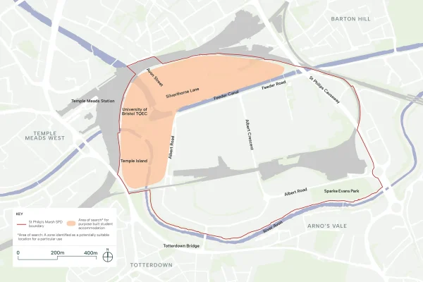
Purpose Built Student Accommodation (SPM 04)
- Purpose-built student accommodation will be subject to the requirements of Policy H7 of the Local Plan 2026.
- PBSA development will be directed to suitable areas in the North West area of St Philip’s Marsh as identified in the diagram and in line with the character area guidance set out in the SPD. These are identified as areas in proximity to the City Centre, University of Bristol Temple Quarter Enterprise Campus and transport infrastructure.
Further information about Purpose Built Student Accommodation (SPM 04)
Purpose-built student accommodation will be subject to the requirements of Policy H7 of the Local Plan 2026.
PBSA development will be directed to suitable areas in the North West area of St Philip’s Marsh as identified in diagram below and in line with the character area guidance set out in the SPD. These are identified as areas in proximity to the City Centre, University of Bristol Temple Quarter Enterprise Campus and transport infrastructure.
Notwithstanding the area of focus identified, any proposed schemes will need to demonstrate that they do not result in a local imbalance of purpose-built student accommodation to the detriment of creating a mixed and balanced community with a variety of uses, including housing, that they are integrated with the surrounding development and public realm and that they include active frontages and incorporate active ground floor uses. Contribution to the community, transport and green infrastructure will be expected in line with wider development.
Background information/ Guidance
Purpose-built student accommodation should be located in close proximity to the Temple Quarter Enterprise Campus, must integrate with surrounding land uses and comply with Policy H7 of the Bristol Local Plan (2026).
Concentrations of student accommodation within one area should be avoided to ensure diversity and the successful integration of these uses within the wider neighbourhood.
The design and management of student accommodation should ensure that buildings feel like a natural part of the neighbourhood rather than isolated, inward-looking developments. This includes considering how entrances, communal spaces and circulation areas relate to the surrounding streets and public realm. Ground floor uses should contribute to the vitality and safety of adjacent streets. Blank frontages, servicing areas and back-of-house functions should not dominate the street edge. Instead, ground floors should be designed to provide activity, natural surveillance and visual interest. Where possible, some amenity provision should be accessible to the wider community.
Student accommodation should be held to the same standards of architectural quality as other residential development. Entrances should be clearly legible and welcoming. Upper floors should provide appropriate articulation that creates visual interest and avoids monotonous or repetitive façades. The scale and massing of development should respond to the surrounding context, with particular attention to the relationship with neighbouring buildings.
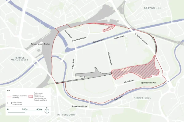
Infrastructure Safeguarding (SPM 05)
- The SPD will reflect the infrastructure safeguarding policy in the Bristol Local Plan. The area shown in the adjacent SPD diagram illustrates the safeguarded infrastructure set out in the Bristol Local Plan.
- The loss of existing transport infrastructure located within these safeguarded areas will be supported if it is demonstrated that they are no longer required.
- Residential-led mixed-use development will be encouraged if the safeguarded area is redeveloped.
Further information about Infrastructure Safeguarding (SPM 05)
Land identified in diagram below will be safeguarded in line with Policy T2A of the Bristol Local Plan (2026).
The loss of existing transport infrastructure located within these safeguarded areas will be supported if it is demonstrated that they are no longer required.
Residential-led mixed-use development will be encouraged if the safeguarded transport infrastructure is redeveloped.
Background information/ Guidance
Policy T2A of the Bristol Local Plan (2026) safeguards land required for potential future transport and movement infrastructure in order to ensure it is not prejudiced by other developments.
St Philip’s Marsh Depot occupies a significant portion of land within St Philip’s Marsh and its potential future redevelopment would unlock substantial opportunities for the neighbourhood. This SPD supports the principle of redevelopment where it can be demonstrated that the land is no longer required for transport purposes.
Redevelopment of the depot would enable new north-south connections through the site, significantly improving permeability and integrating the neighbourhood more fully between character areas. In addition, it could deliver new active travel routes using the existing railway bridge at Albert Crescent to connect with wider Bristol.
This redevelopment also presents an opportunity to deliver new open space, contributing to the network of green infrastructure across St Philip’s Marsh and supporting biodiversity and ecological connectivity.
Should the depot be released for development, residential-led or workplace development will be supported in this location. The scale of the site offers the potential for a significant number of new homes or employment floorspace. Any development should integrate with the surrounding character areas and enhance connections to the wider neighbourhood.
Social infrastructure and community facilities (SPM 06) & Education (SPM 07)
- Social infrastructure, including health and education facilities, and community facilities, such as community centres, childcare facilities and places of worship, will be supported and steered towards locations in proximity to the identified District / Local Centres.
- The SPD will identify an area that meets the accessibility requirements for a new Primary School in St Philip’s Marsh.
- Note: District centres serve a wider area with a greater mix of shops and services, whilst local centres provide everyday conveniences within walking distance of homes.
Further information about Social infrastructure (SPM 06) & Education (SPM 07)
Social infrastructure (SPM 06)
Development within the SPD boundary will be expected to provide social infrastructure, including community facilities.
To achieve comprehensive redevelopment of St Philip’s Marsh, qualifying development proposals will be required to deliver or contribute towards collective infrastructure requirements, services and community facilities, including those that will be set out in infrastructure delivery table.
Social infrastructure and community facilities should be located in proximity to identified local centres where there is a choice of travel options and opportunity for linked trips to ensure accessibility for all members of the existing and future community. The provision of social infrastructure within mixed-use buildings will be supported where appropriate with future management arrangements.
The loss of community facilities will not be supported unless it has been demonstrated through suitable evidence in line with Policy CF2 of the Bristol Local Plan (2026).
Education (SPM 07)
Development within the SPD boundary will be expected to deliver education provision and contributions in line with Policy CF1 of the Bristol Local Plan (2026) and infrastructure delivery table.
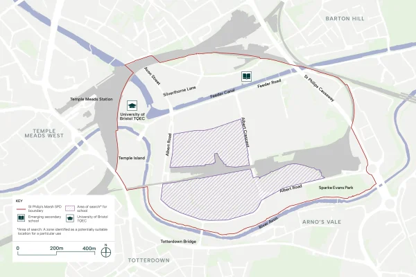
To meet accessibility requirements for the regeneration area, a new Primary School must be delivered within the SPD boundary in the Area of Search indicated in the diagram below and in line with the Bristol City design requirements.
Subject to further engagement with the Bristol Education team, this is currently envisaged to include early years provision, on-site student support centre and be co-located with nearby open space.
Education development will be expected to be well designed, with clearly legible entrances, high quality internal spaces and, child friendly internal and external environments. Education development must be connected by safe and direct walking and cycling routes to the community / neighbourhood they serve.
Background information/ Guidance
St Philip’s Marsh will become a place where people can access the services and facilities they need to live well—schools for children, healthcare for all ages, and spaces where communities can come together.
Social infrastructure refers to the wide range of services, facilities and physical spaces that meet local community and strategic needs. Community facilities are defined in the Bristol Local Plan (2026) as including community centres, childcare facilities, cultural venues, places of worship, education and training, health and social care facilities, sports and recreation, and, civic and administrative facilities.
Policy CF1 of the Bristol Local Plan (2025) requires community facilities to be located where there is a choice of travel options and is accessible for all. Policy CF2 seeks the retention of community facilities.
Currently, St Philip’s Marsh has limited social infrastructure, reflecting its recent industrial character. The regeneration offers an opportunity to address this gap, creating facilities that will serve both new residents and existing communities in surrounding areas who currently lack convenient access to local services.
The location of community facilities is critical to their success. Positioning schools, healthcare and community spaces within or adjacent to the district and local centres, or alongside principal open spaces, will bring activity to these areas and create vibrant neighbourhood focal points. These locations have been identified to ensure safe, walkable access from all parts of St Philip’s Marsh and from established communities beyond the site boundary, strengthening connections rather than creating barriers.
Where appropriate, the repurposing and making best use of listed buildings and existing buildings of architectural interest is encouraged, recognising that these structures embody the industrial heritage of the site and provide distinctive settings for social infrastructure.
Community facilities will play a role in placemaking, particularly in the early phases of development. The early delivery of a community space, school or health facility can establish a sense of identity and belonging before the neighbourhood is fully built out, providing an anchor around which the community can form.
Community uses at ground floor level within new developments are also supported, particularly where they front open spaces and key public realm areas.
As the residential population grows and family homes are delivered, convenient access to high-quality primary schools will be essential for families.
The Area of Search identified has been selected to ensure the primary school is positioned within a 15-minute walk of all residential areas, supporting active travel and reducing reliance on car journeys for the school run.
Primary schools should be located adjacent to principal open spaces, enabling efficient use of land through shared playing fields and outdoor learning areas. Locations in areas of low vehicular traffic and adjacent to active travel corridors are prioritised, ensuring safe and convenient access by walking and cycling.
Positioning primary schools in close proximity to other community facilities and services is encouraged, enabling families to combine trips and supporting convenient routines of daily life.
Development proposals should demonstrate efficient use of land whilst meeting Bristol City Council’s requirements for quality, capacity and design standards.
Planning permission for a secondary school off Silverthorne Lane has been approved and is currently being built out. The location of which is highlighted in diagram above. It is not envisaged that the direct delivery of a secondary school is required in the SPD boundary.
District and Local Centre Uses (SPM 08)
- Shops, businesses, and community services that meet the everyday needs of local residents and workers will be encouraged and directed towards the District and Local Centres.
- Residential uses on the upper floors of the District / Local Centres will be supported.
- Note: District centres serve a wider area with a greater mix of shops and services, whilst local centres provide everyday conveniences within walking distance of homes.
Further information about District and Local Centre Uses (SPM 08)
Town centre uses which meet the day-to-day needs of local residents and employees will be expected to be concentrated within the District / Local Centres, located within the areas shown in diagram below.
Community-focused uses, such as healthcare facilities, will also be supported.
A town-centre first approach will be applied for town centre use development in line with national policy and Policy SSE4 of the Bristol Local Plan (2026). Any town centre uses proposed outside of the identified District and Local Centres must submit a sequential test.
Uses must contribute to the vibrant mixed-use District / Local Centres, supporting the vitality and viability of the Centre. A retail impact assessment will be required in line with national policy and Policy SSE4 of the Bristol Local Plan (2026).
Active frontages within the District / Local Centres will be expected. Residential uses on the upper floors of town centre uses will be supported, subject to compliance with the Bristol Local Plan (2026) and without compromising amenity of residents.
Opportunities for multi-functional uses for footfall-generating activities, such as markets, will be encouraged.
Background information/ Guidance
The creation of vibrant district and local centres is essential to establishing St Philip’s Marsh as a complete neighbourhood.
Policy SSE1 to SSE4 of the Bristol Local Plan (2026) set out the importance of centres in meeting a range of local needs, and seeks the vitality, viability and diversity of centres. Town centre uses are defined in the National Planning Policy Framework.
District and local centres within St Philip’s Marsh will become focal points for community life, building on the emerging identity of the area and bringing distinct character to each cluster.
The district centre will serve as a destination for the wider city—an attractive place with a concentration of retail, restaurants, bars, community facilities and services that draws visitors from St Philip’s Marsh and neighbouring areas. Its role extends beyond meeting daily needs, offering a mix of uses that creates activity throughout the day and into the evening.
Local centres fulfil a different function, ensuring that everyday needs can be met within a five to ten-minute walk from home. These centres will accommodate services and community facilities with a more local character.
The location of centres has been identified to ensure they are accessible via safe and convenient walking and cycling routes. Active ground floor uses within these centres create vibrant outdoor spaces that encourage social gathering and community interaction.
Cultural and Meanwhile Uses (SPM 09)
- Meanwhile uses will be supported to activate vacant or underutilised space at early phases of development, subject to not prejudicing long-term development.
- The phased nature of comprehensive development, being built out over a number of years, creates opportunities for creative and innovative meanwhile uses, in line with Policy SSE5 of the Bristol Local Plan (2026).
- Planning applications within the SPD boundary should consider retaining and sensitively relocated existing cultural uses if feasible.
Further information about Cultural and Meanwhile Uses (SPM 09)
Meanwhile uses play a vital role in the early stages of regeneration, bringing activity and identity to St Philip’s Marsh before long-term development is fully realised. These temporary uses will create early destinations for Bristolians to discover the site, helping to establish a sense of place and build awareness of the emerging neighbourhood.
The activation of vacant or underutilised spaces through cultural, creative and community uses is encouraged, subject to not prejudicing long-term development coming forward under this SPD.
Meanwhile uses offer an opportunity to celebrate Bristol’s creative spirit, providing affordable space for artists, makers and community organisations to establish a presence and contribute to the evolving character of the area. Such uses can test new ideas, generate footfall and foster social connections that will endure as the neighbourhood matures.
In the longer term, cultural uses will continue to shape the identity of St Philip’s Marsh. The retention of existing cultural uses and their integration within new development is encouraged, ensuring that established creative activities and communities can remain part of the neighbourhood as it evolves. The reuse of listed buildings and buildings of architectural interest for cultural purposes is also supported, recognising that these structures embody the industrial heritage of the site and provide distinctive settings for creative activity.
Cultural uses at ground floor level within new developments are also supported, particularly where they front open spaces and key public realm areas. These uses contribute to active streetscapes, animate public spaces and reinforce the role of culture in defining the character of St Philip’s Marsh.
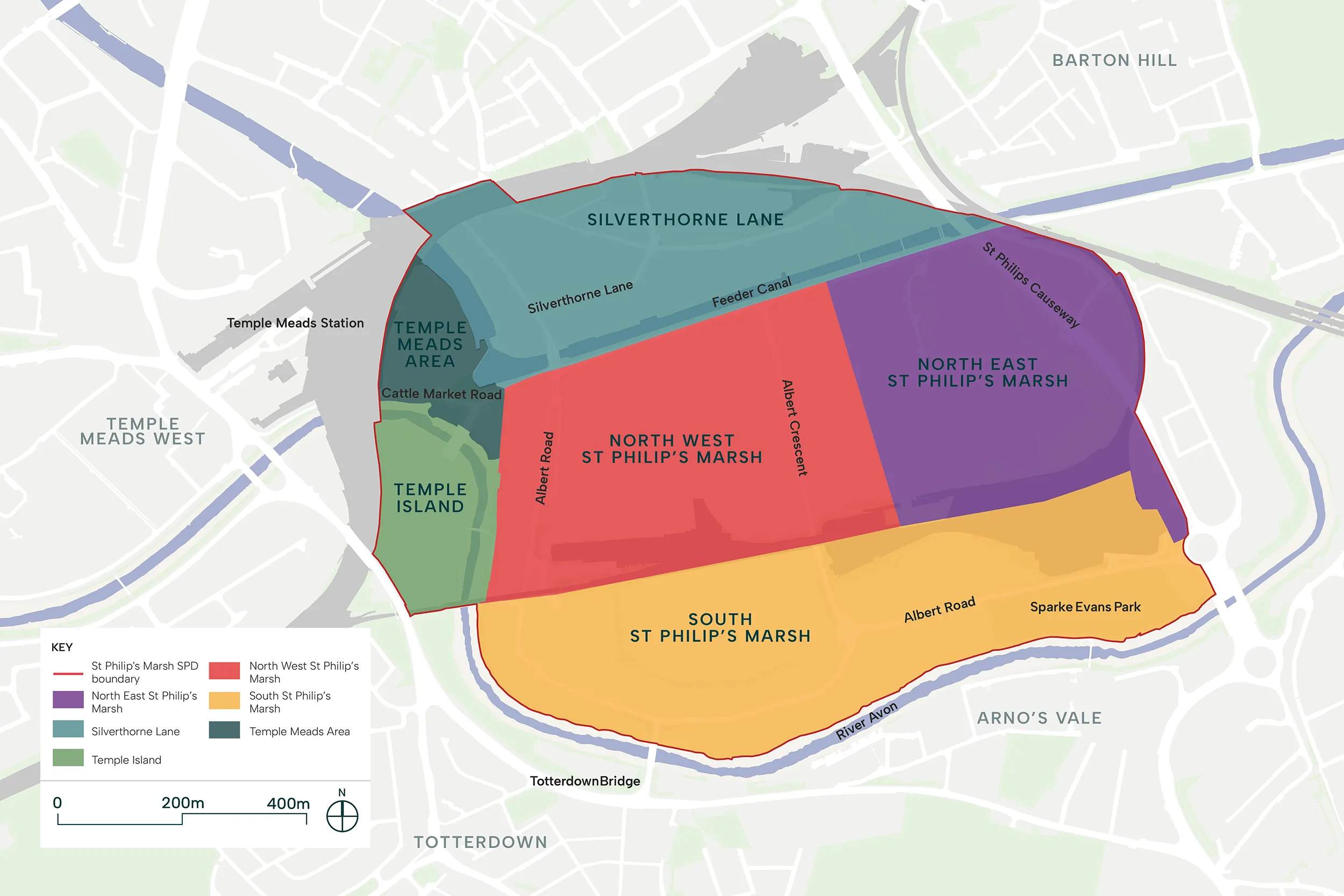
6. Character areas
The division of St Philip’s Marsh into character areas is fundamental to creating a diverse, legible and comprehensive neighbourhood. Each character area responds to its specific context, defined by the natural and man-made features that structure the site. The SPD principle calls out the six character areas and requirement for new development to respond to character area specific guidance.
Character areas (SPM 23)
In line with Policies DS2 and DS3 of the Bristol Local Plan (2026), St Philip’s Marsh comprises six distinct character areas including:
- Silverthorne Lane: A mixed-use area with homes, workspace, student accommodation, leisure, and education.
- Temple Island: New homes, workspace, and student accommodation linked to the Temple Quarter Enterprise Campus.
- Temple Meads Area: A modern transport hub at Bristol Temple Meads with nearby sites supporting the interchange.
- North West St Philip’s Marsh: A vibrant mixed-use area with high density, knowledge-based workspace.
- North East St Philip’s Marsh: Optimum location for campus-style industrial development.
- South St Philip’s Marsh: A sustainable, residential-led mixed-use neighbourhood along the River Avon ecological corridor.
Development coming forward within the relevant character area will be required to respond to the character-area specific guidance, alongside the relevant extract from the Local Plan.
Read more details from the draft SPD about each character area below.
Silverthorne Lane, Temple Meads Area and Temple Island
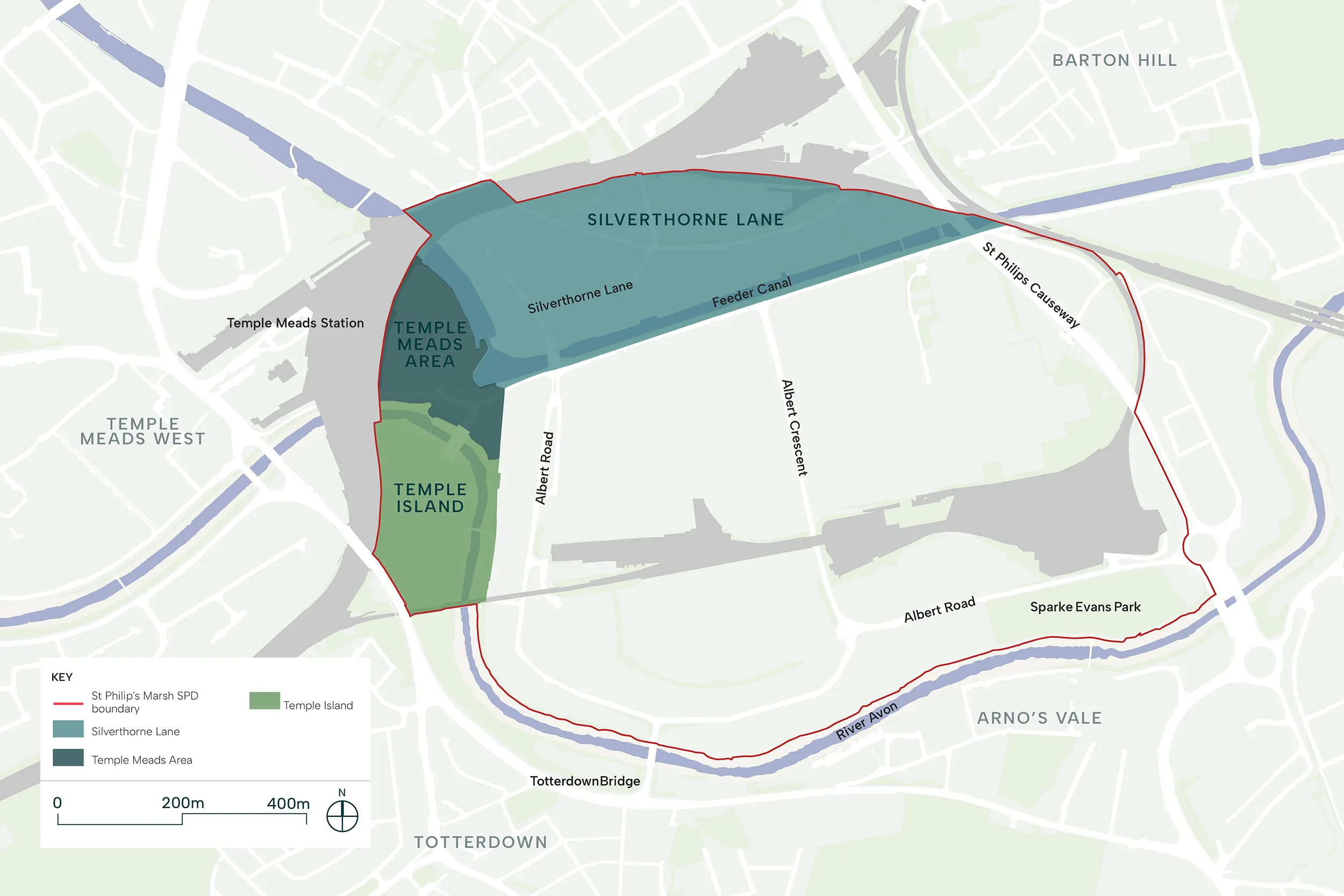
Silverthorne Lane and Temple Meads Area
Silverthorne Lane, consists of the conservation area north of the Feeder Canal, and Temple Meads Area is the land immediately east of Bristol Temple Meads Station, where the University of Bristol Temple Quarter Enterprise Campus is located.
The key features defining the character of this area are:
- Heritage identity: The character of this area is rooted in its industrial past. Development should retain architectural features, materials and components that reference the historic architectural language predominant in this area. The sensitive retention, refurbishment and repurposing of heritage assets and listed structures is encouraged for education, cultural or social uses so they are more accessible to the wider public.
- Relationship to Bristol Temple Meads: The close proximity to Bristol Temple Meads Station, a Grade I listed building, requires all development in this area to be respectful of and sympathetic to this significant heritage asset and its setting.
- Knowledge-based uses: The presence of the University of Bristol Temple Quarter Enterprise Campus defines the function of this cluster. Land uses related to knowledge-based workspace—such as research, education and innovation—will be promoted to complement the university and benefit from proximity to the train station. Student residential accommodation will also be supported in this location.
- Active ground floors: Given the footfall generated by the university and the station, active ground floor uses are encouraged towards the Feeder Canal and the eastern entrance to Bristol Temple Meads Station to animate streets and create vibrant, welcoming spaces.
- Public realm and arrival: As the principal arrival point into St Philip’s Marsh from Bristol Temple Meads, the quality of public realm is critical. Development should deliver generous, legible spaces that guide visitors into the wider area, with clear wayfinding and a welcoming experience that establishes the identity of St Philip’s Marsh from the outset.
- The Feeder Canal: The canal is a defining feature of this cluster. Development should deliver high-quality architecture and public realm along its length, ensuring that buildings positively address the water and strong relationships are established between development, public realm and the canal.
Temple Island
Temple Island is the land bound by the River Avon to the east, and the railway tracks to the west.
The key features defining the character of this area are:
Relationship with the River Avon: This cluster has a strong relationship with water, as the River Avon runs through the centre of the area. Development proposals should enhance the river edge, promoting active travel along the waterfront whilst maximising the ecological potential of this blue asset. Buildings should open up towards the river, maximising views and activity along this edge. evelopment must also respond to flood risk and align with the Avon Riversides 2100 (formerly Bristol Avon Flood Strategy).
Mixed-use character: The proximity to the knowledge based uses in Temple Meads Area and the district centre will shape the character of this area. Mixed-use development that supports both the university and the wider neighbourhood will be promoted. Student residential accommodation will also be supported in this location.
Strategic visibility and arrival: This area occupies a highly visible location, seen from Bath Road, the railway and Cattlemarket Road—a principal access route into the site. Development should therefore be welcoming and inclusive, creating high-quality public realm that invites visitors to walk and cycle. Consideration should be given to outdoor comfort and the quality of the pedestrian environment.
Building scale and landmarks: Given its strategic visibility, this area is suitable for taller buildings that can act as landmarks and aid wayfinding. Building heights should respond to the prominent location whilst respecting the setting of nearby heritage assets and ensuring appropriate relationships with neighbouring development.
North West St Philip’s Marsh
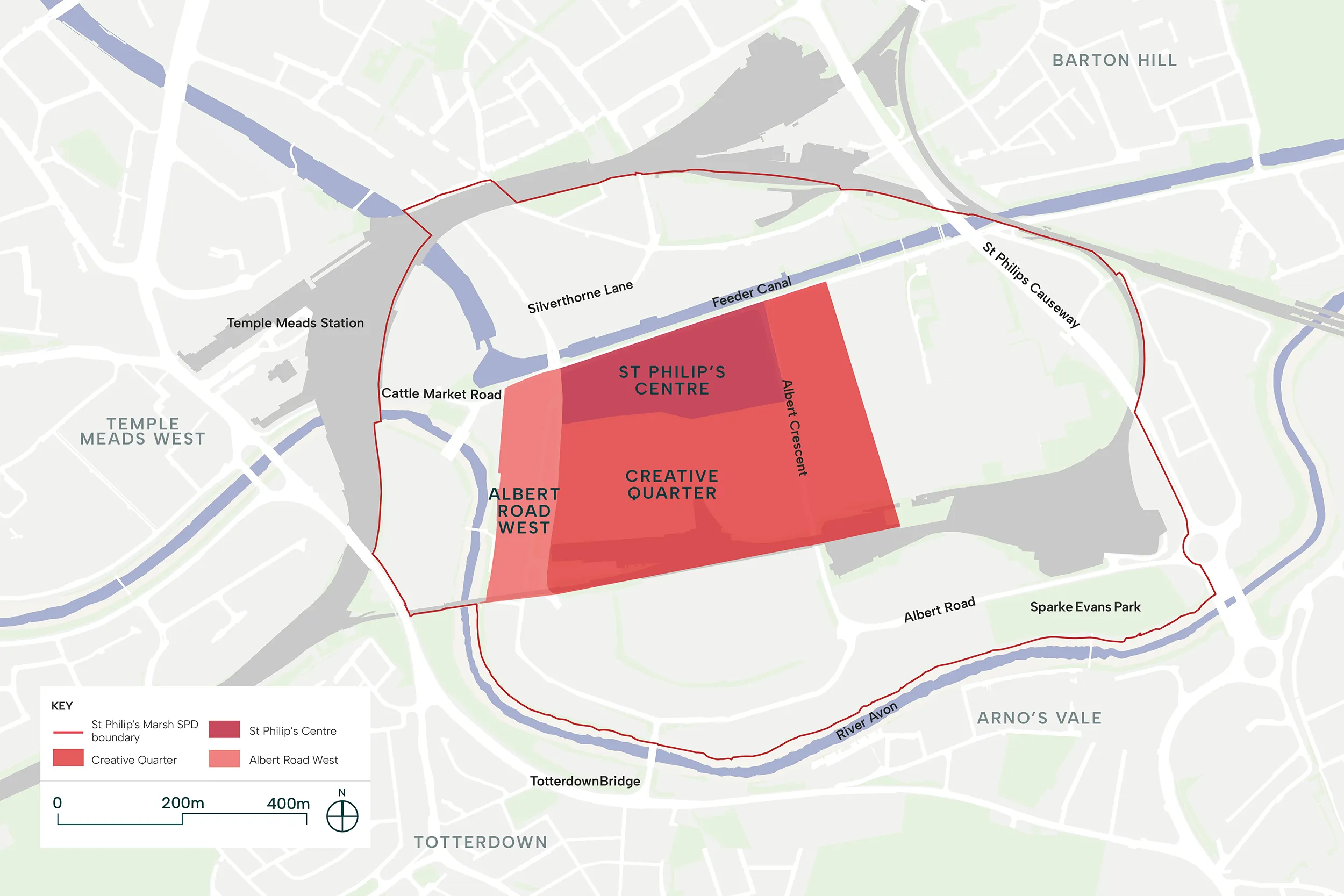
North West St Philip’s Marsh
North West St Philip’s Marsh occupies a strategic position at the threshold between the city centre and the wider regeneration area. As the primary gateway into St Philip’s Marsh from Bristol Temple Meads, this character area will play a defining role in establishing the identity and success of the neighbourhood.
The Feeder Canal is the central structuring element of this cluster, a heritage asset that once served as the catalyst for the industrial expansion of St Philip’s Marsh. The regeneration offers an opportunity to restore its prominence as a focal point for activity, movement and public life.
The proximity to Bristol Temple Meads and the emerging Temple Quarter Enterprise Campus positions this area as a natural extension of the city centre. High-intensity, knowledge-based workspace will be concentrated here, fostering an economic ecosystem where innovation, research and enterprise can thrive.
North West St Philip’s Marsh is envisaged as a mixed-use cluster. Residential development will be supported where it contributes to a vibrant, balanced community. The combination of uses—rooted in the setting of the Feeder Canal—will create a sense of place and belonging.
Chapel Street, Albert Crescent and Albert Road provide further structure to this cluster, establishing the principal routes and dividing this area into sub-character areas.
St Philip’s Centre
St Philip’s Centre is to become the main destination in St Philip’s Marsh, a district centre that serves not only the residents and workers within the Marsh but also the wider Bristol area.
This district centre is bound by the Feeder Canal to the north, Chapel Street to the south, Albert Road to the west and Albert Crescent to the east. This location provides excellent connections to and from wider Bristol and will be easily accessible by public transport, with the train station adjacent and bus services serving the area. Enhanced walking and cycling connections will further improve accessibility.
The key features defining the character of the area are:
- Feeder Canal: The Feeder Canal is a heritage asset and is central to the masterplan’s ambition to restore activity and vibrancy along the waterfront, highlighting the value of this historic feature. Development in this area will prioritise the waterfront, with buildings opening up towards and addressing the water. The existing Feeder Road in this area is to be pedestrianised, providing a safe and welcoming public realm with a strong relationship to the canal. Increased soft landscaping will ensure that flood defence infrastructure is well integrated within the landscape design. Active ground floors within this area will enhance vibrancy and support the liveability of the neighbourhood.
- Mixed-use character: As the main destination within St Philip’s Marsh, this cluster must provide a mixed-use frontage along the waterfront, integrating different land uses to ensure activation throughout the day and year-round. Services, retail and community uses will be concentrated at ground floor level.
- Evening economy: Restaurants, bars and cultural uses are encouraged within St Philip’s Centre to support a vibrant evening economy, creating a destination that is animated throughout the day and into the evening.
- Public spaces and gathering: St Philip’s Centre should incorporate a generous public square and other gathering spaces that can accommodate events, markets and community activities. The main square will provide a focal point for social interaction and reinforce the role of the district centre as the heart of St Philip’s Marsh. The design of public spaces must consider accessibility and the requirements of people with disabilities and additional needs, ensuring a safe, inclusive and welcoming outdoor environment for all.
- Building heights and landmark potential: As the district centre and principal destination, St Philip’s Centre is suitable for taller buildings at key nodes, marking key corners and gateways and creating a varied and interesting roofline.
- Reinterpretation of industrial character: There are few historic industrial buildings within this cluster. However, its close proximity to the conservation area means that development must be in keeping with the character of the area, building upon the identity of the site as an industrial place bounded by water. The reinterpretation of industrial architectural language, materials and detailing is encouraged, alongside the integration of green and blue infrastructure. The use of timber and other low-carbon construction methods is also encouraged, showcasing innovative approaches to sustainable architecture. The reuse, refurbishment and repurposing of the existing locally listed Jubilee Hall is supported.
- Relationship to adjacent clusters: St Philip’s Centre will become the heart of St Philip’s Marsh and must function as a hub that connects and serves the surrounding sub-character areas. Strong pedestrian and cycle connections, including a new pedestrian bridge aligned with the new plaza, will link this area to all other clusters to ensure the district centre is easily accessible from all parts of the neighbourhood.
Creative Quarter
The Creative Quarter bridges St Philip’s Centre with the quieter residential areas of St Philip’s Marsh. This cluster is bounded by Chapel Street to the north, Albert Road to the west and the Network Rail depot to the south. These key routes ensure the area is well connected by public transport, cycling, walking and vehicle.
The key features defining the character of this area are:
- Mixed-use character: This mixed-use cluster supports, complements and builds upon the active uses concentrated in St Philip’s Centre. The area will provide the residential critical mass needed to support the activation of the North West cluster throughout the day and year-round. Ground floor uses such as light industrial activities that can be co-located with residential, commercial spaces and community infrastructure will be encouraged. Facilities that respond to the needs of residents and workers in St Philip’s Marsh—such as schools and nurseries—will be located in this area. The location of a Skills Centre bridging the Creative Quarter and the North East St Philip’s Marsh will be supported.
- Recreational park: This cluster will deliver a large green space for recreation, gathering and play. The open space will become a key destination for residents, workers and visitors. Locating community infrastructure around this park is encouraged, alongside ground floor uses that include affordable workspaces, cultural and recreational uses.
- Active ground floors: Active ground floor uses are expected along the edges of the recreational park and key routes such as Chapel Street. These uses will contribute to natural surveillance, animate the public realm and create welcoming streets.
- Building form: Development within this cluster should adopt a human-scale approach. Taller buildings should be concentrated along Albert Road and Albert Crescent, and adjacent to large open spaces. Variety in commercial and residential typologies is encouraged, including the delivery of houses in strategic locations within the quieter, central parts of this cluster. Block dimensions should contribute to the creation of a walkable neighbourhood with a fine grain and permeable street grid. Streets and spaces must be appropriately framed, with continuous façade lines that define the public realm. The relationship between building heights and street widths should provide a range of spatial experiences. Tertiary streets should be designed not only for movement but also to invite people to gather and engage in informal play.
- Green streets: Soft landscaping and sustainable drainage systems (SuDS) are encouraged within the outdoor spaces and streets of this cluster, particularly those connecting the recreational park to other key outdoor spaces.
Albert Road West
The Albert Road area is located west of Albert Road, bounded by the Network Rail depot to the south, Cattlemarket Road to the north, the River Avon and Temple Island to the west, and Albert Road to the east.
The key features defining the character of this area are:
- Relationship with the River Avon: This cluster has a strong relationship with the River Avon. Development proposals should enhance the river edge, promoting active travel along the waterfront whilst maximising the ecological potential of this blue asset. Buildings should open up towards the river, maximising views and activity along this edge. Massing should create a varied façade line along the river, with on-plot landscape opening up towards the water where possible, allowing the ecological corridor to expand and contract. Development must also respond to flood risk and align with the evelopment must also respond to flood risk and align with the Avon Riversides 2100 (formerly Bristol Avon Flood Strategy).
- Mixed-use character: The proximity to the knowledge based uses in Silverthorne Lane and Temple Meads Area and the district centre will shape the character of this area. Mixed-use development that supports both the university and the wider neighbourhood will be promoted. Student residential accommodation will also be supported in this location.
- Strategic visibility and arrival: This area sits along a principal access route into the site, Cattle Market Road and Albert Road. Development should therefore be welcoming and inclusive, creating high-quality public realm that invites visitors to walk and cycle. Consideration should be given to outdoor comfort and the quality of the pedestrian environment.
- Building scale and landmarks: Given its strategic visibility, this area is suitable for taller buildings that can act as landmarks and aid wayfinding. Building heights should respond to the prominence of their location whilst respecting the setting of nearby heritage assets and ensuring appropriate relationships with neighbouring development.
- Albert Road and Victoria Street: Albert Road plays a critical role in connecting this cluster with the rest of St Philip’s Marsh. The street will be enhanced to ensure safe movement for all transport modes. The existing parallel route, Victoria Street, is to be transformed into a linear park hosting active travel corridors. This linear park will define the boundary of this cluster and provide a connection to the district centre.
South St Philip’s Marsh
South St Philip’s Marsh
South St Philip’s Marsh is the area south of the Network Rail depot and north of the River Avon. This cluster is the main gateway from the southern communities via Totterdown Bridge and St Philips Causeway.
This area presents the opportunity to extend the residential character of the existing communities south of the site into St Philip’s Marsh, enabling the delivery of a strong residential community with sufficient critical mass to unlock community infrastructure. This also creates continuity to southern neighbourhoods like Totterdown and St Anne’s.
The River Avon creates a strong edge to this cluster whilst providing a key connection into wider Bristol. This geographical feature played an important role in the site’s history as an industrial area. Reintegrating the river into the fabric of St Philip’s Marsh by reinstating it as a key route into and out of the site, and maximising its potential for biodiversity and ecology should be a priority for any development within this cluster. Development must also respond to flood risk and ensure that flood defence infrastructure is delivered and well integrated within the landscape design.
Sparke Evans Park is another key feature, which will be regenerated to revitalise the park. Development should ensure that the area is connected to the park through green streets, open spaces and landscaping.
Albert Crescent, Albert Road and a new active travel corridor parallel to Albert Road will further articulate this area, subdividing it into sub-clusters with different characters.
Riverside Community
The Riverside Community is located immediately north of the River Avon and is bounded by Albert Road to the north.
The key features defining the character of this area are:
- Relationship with the River Avon: This cluster has a strong relationship with the River Avon. Development proposals should enhance the river edge, promoting active travel along the waterfront whilst maximising the ecological potential of this blue asset. Buildings should open up towards the river, maximising views and activity along this edge. Massing should create a varied façade line along the river, with on-plot landscape opening up to the water where possible, allowing the ecological corridor to expand and contract. Development must also respond to flood risk and align with the evelopment must also respond to flood risk and align with the Avon Riversides 2100 (formerly Bristol Avon Flood Strategy).
- Albert Road: Albert Road is a key route connecting St Philip’s Marsh with wider Bristol. It is to become a traditional street, with enhanced pedestrian footways and a reduced carriageway. Development should frame Albert Road with a continuous façade line that defines the street and provides a sense of enclosure.
- Active ground floors: This residential-led development will be supported by active ground floors and residential amenity spaces that animate Albert Road and key open spaces. Services, retail and community infrastructure should be clustered around key open spaces and gateways into the site, offering residents convenient access to everyday needs.
- Massing and form: Innovative typologies should be explored to deliver high-quality residential developments that respond to different family and household types. Due to the location and principal orientation of development within this cluster, massing must be carefully considered to ensure outdoor comfort, avoiding wind tunnels and ensuring best practice sunlight access to streets, outdoor spaces and courtyards, as well as adequate daylight levels within all residential units.
- Albert Road Corporation Garage: The Albert Road Corporation Garage is a locally listed structure within this cluster. The repurposing, refurbishment and reuse of this building for community purposes is encouraged, along with the creation of high-quality public realm around it.
- Active travel corridor: An active travel corridor with substantial landscaped areas is to be delivered along the boundary between this cluster and the Fruit Market Neighbourhood.
- Sparke Evans Park: Sparke Evans Park is to be regenerated, restoring its historic components and design intentions whilst enhancing its ecological and biodiversity performance.
Fruit Market Neighbourhood
The Fruit Market Neighbourhood sits north of the Riverside Community, bounded by the Network Rail depot to the north, Albert Crescent to the east and the new active travel route to the south.
The key features defining the character of this area are:
- Topography: This cluster presents a significant level change. A large portion of the area is elevated, which presents both an opportunity and a challenge. It is one of the few areas within the SPD boundary outside the flood zone, but the level change also creates connectivity issues and limits permeability to adjacent clusters. Development should redesign this level change to provide softer gradients through landscape areas, and improve visual and physical connectivity to neighbouring clusters, in particular the Riverside Community.
- Relationship to the Network Rail depot: The northern edge of this cluster is adjacent to the Network Rail depot. Development should provide green ecological buffers along this boundary, offering screening and acoustic mitigation whilst maximising opportunities for biodiversity and habitat creation.
- Massing and form: Diverse typologies and a varied roofscape are encouraged. As this cluster has a higher proportion of land outside the flood zone, the delivery of townhouses and mews street typologies is supported. This will create a family-oriented cluster with strong community bonds.
- Streets and movement: This cluster will have minimal vehicular traffic, with access limited to servicing and residents only. Streets should be designed with a human scale, creating safe, welcoming environments that invite informal play and social interaction. The low-traffic character of this area will reinforce its family-oriented identity.
- Green streets and sustainable drainage: Soft landscaping and sustainable drainage systems (SuDS) are encouraged throughout this cluster. Given the topography and level changes, the integration of SuDS within streets and open spaces will help manage surface water run-off whilst contributing to the green character of the neighbourhood.
- Community park: A community park is to be delivered in this area, strategically located in close proximity to the level change. This park will help navigate the change in topography whilst providing areas for play, flexible outdoor spaces for gathering and sports, and landscaped areas for ecology and biodiversity. The park will help integrate this cluster with the Riverside Community whilst delivering a green open space that builds strong community bonds and promotes the health and wellbeing of residents.
Parkside Neighbourhood
The Parkside Neighbourhood sits east of the Fruit Market Neighbourhood, bounded by the Network Rail depot to the north, Albert Road to the south, Albert Crescent to the west, St Philips Causeway to the east and adjacent to Sparke Evans Park.
The key features defining the character of this area are:
- Albert Road and Albert Crescent: Albert Road and Albert Crescent are key routes connecting St Philip’s Marsh with wider Bristol. Development should frame these streets with a continuous façade line that defines the street and provides a sense of enclosure.
- Massing and form: This cluster will combine a mix of housing typologies. Taller buildings should be located along Sparke Evans Park and at key junctions, whilst mid and low-rise typologies create human-scale, inviting streets within the cluster. The delivery of family homes is encouraged in this area, with potential for townhouses or similar typologies within the centre of the cluster.
- Sparke Evans Park: The adjacency to Sparke Evans Park is a defining feature of this cluster. Development should positively address the park, with frontages that provide natural surveillance to create a safe and vibrant edge. Residents will benefit from convenient access to this key community open space.
- Relationship to the Network Rail depot: The northern edge of this cluster is adjacent to the Network Rail depot. Development should provide green ecological buffers along this boundary, offering screening and acoustic mitigation whilst maximising opportunities for biodiversity and habitat creation.
- Green streets and sustainable drainage: Soft landscaping and sustainable drainage systems (SuDS) are encouraged throughout this cluster. Green streets will connect the ecological buffer to Sparke Evans Park, reinforcing the green character of the neighbourhood.
North East St Philip’s Marsh
North East St Philip’s Marsh
North East St Philip’s Marsh is located south of the Feeder Canal and immediately west of St Philips Causeway. This area provides the opportunity to bridge the new mixed-use development in the North West cluster with the existing Avonmeads retail park and Avonside industrial park to the east, beyond the SPD boundary. This area is key to ensuring the continuity of the site’s contribution to Bristol’s economy.
Due to the proximity to large-scale infrastructure such as the Network Rail depot to the south, National Grid infrastructure and St Philips Causeway, this area is the optimum location for the consolidation of industrial uses. Development in the North East St Philip’s Marsh will promote the consolidation and intensification of industrial land uses, and where possible the co-location of industrial with other uses such as commercial, residential or community. The use of innovative typologies that enable the retention of industrial uses through more efficient use of land will be encouraged.
Development in the North East St Philip’s Marsh will aspire to provide a campus-style cluster where cycling and walking are safe and convenient. Access to this area and the servicing of industrial buildings should be managed without impacting other clusters. Proposals should prioritise active travel modes and public transport for employees. Where possible, parking should be consolidated in Mobility Hubs—facilities that serve multiple businesses, and provide car parking, cycle infrastructure and other sustainable transport provisions.
The key features defining the character of the North East St Philip’s Marsh are:
- Feeder Canal: Development along the Feeder Canal will enable the delivery of an enhanced green area along the canal, flood defence infrastructure and improved walking and cycling connections.
- Building typologies: Development should explore innovative building typologies that consolidate and intensify industrial uses. Where possible, industrial land uses should be stacked across multiple floors or co-located with other uses such as residential, community or commercial.
- Outdoor spaces: Streets and on-plot outdoor spaces should incorporate soft landscaping and sustainable drainage systems (SuDS). Whilst meeting the operational requirements of businesses, outdoor spaces should be designed efficiently to reduce the heat island effect through landscape and planting. Surface car parks and service yards should be designed to minimise their visual impact, with service areas and parking screened from the street where possible.
- Streets: Where possible, streets should be framed by development to maximise natural surveillance and activation of the streetscape. Where setbacks are required, landscaped areas should be used to provide privacy and security, avoiding fences or tall walls that create an unwelcoming environment.
- Integration with adjacent clusters: The integration of this cluster with adjacent areas is essential to ensure that development across the SPD boundary comes forward in a comprehensive manner. Denser buildings are encouraged towards the west, adjacent to the Creative Quarter, to maximise vibrancy and movement around the local centre along Albert Crescent.
- Sustainable design: Development should showcase innovative, sustainable construction technologies. This will demonstrate new approaches to employment development, not only aligning with but also promoting Bristol’s net-zero ambitions. The use of low-carbon construction methods and energy-efficient building design is also encouraged.
- Skills and training: A skills and training centre is encouraged on the boundary between the Creative Quarter and the North East St Philip’s Marsh. Development within the North East St Philip’s Marsh should support local employment and training opportunities that enable local residents to benefit from the economic activity in this area.
- Green infrastructure and ecological buffers: Development should provide green ecological buffers along the boundary with the Network Rail depot, maximising opportunities for biodiversity and habitat creation.
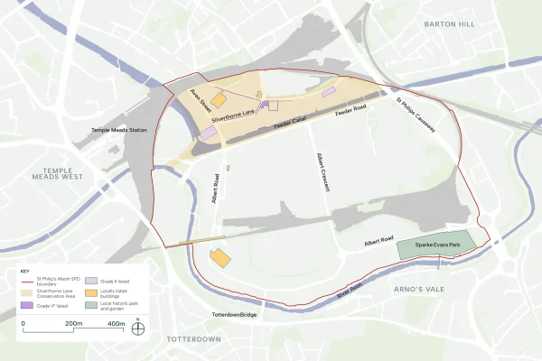
Heritage (SPM 13)
Planning applications within the SPD boundary will be expected to consider the existing heritage assets on site.
Further information about Heritage (SPM 13)

Heritage
The SPD encourages the sensitive repurposing, refurbishment and reuse of listed buildings and existing buildings of architectural interest for community, cultural, educational or commercial uses. These structures embody the industrial heritage of the site and provide distinctive settings for new activities that bring life to the neighbourhood.
The regeneration presents an opportunity to equalise access to St Philip’s Marsh’s heritage assets. The Feeder Canal, once an industrial working waterway, will become a public destination at the heart of the neighbourhood—accessible to all through the creation of the Feeder Promenade and square.
New development should draw upon the industrial heritage of the site, reinterpreting its architectural language, materials and detailing to create a cohesive identity rooted in place. This does not mean replication, but rather a thoughtful response that acknowledges the past whilst creating buildings and spaces fit for the future.
Policy CHE1 of the Bristol Local Plan (2026) aims to ensure that the heritage legacy of Bristol is stewarded with sensitivity, creating and innovation to ensure that the benefits it brings continue to be realised into the future. Great weight is placed on the conservation of designated heritage assets. Non-designated heritage assets should also be conserved with regards to their significance.
7. Green and blue infrastructure
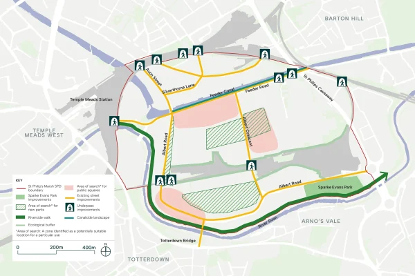
An accessible, well-connected network of green and blue spaces will be central to creating a neighbourhood where people choose to spend time outdoors, where children can play safely, and where neighbours meet. The SPD principles related to blue and green infrastructure will guide future development, ensuring that everyone living and working in the area has quality outdoor space within a short walk. It will also ensure that flood defence measures are delivered in a coordinated way to mitigate future flood risk across the site.
Green and blue infrastructure (SPM 10), (SPM 11), (SPM 12)
- The SPD identifies a green and blue infrastructure network within St Philip’s Marsh, including the retention of Sparke Evans Park.
- New developments must provide high-quality landscaping, including sustainable drainage systems (SuDS), and contribute towards public realm improvements.
- Proposals that increase tree canopy cover will be supported.
- New developments next to the River Avon or Feeder Canal should take opportunities to restore and improve the water environment for ecology, leisure and visual amenity.
- New developments must provide policy-compliant levels of open space and play provision. Landowners and developers will be encouraged to work together to ensure an appropriate size and scale of green and open space is provided.
- Biodiversity net gain will be required.
Further information about Green and blue infrastructure (SPM 10), (SPM 11), (SPM 12)
Green and blue infrastructure
(SPM 10)
All development proposals should consider and enhance the blue and green infrastructure network within the SPD boundary, and take opportunities to enhance and increase ecology and biodiversity, in line with Policy BG1 to BG5 of the Bristol Local Plan (2026).
An interconnected network of multifunctional, inclusive and accessible open spaces for all ages must be provided in line with the key green and blue infrastructure illustrated in the Framework Plan (in page 4 of this Digital Hub).
Sparke Evans Park must be retained and any adjacent application must demonstrate that its utility is not impacted. All applications will be expected to provide high quality soft and hard landscaping features, which support and improve biodiversity, and integrate sustainable urban drainage systems (SUDS). Qualifying development will also be expected to contribute to public realm improvements, including improvements to the setting of the River Avon and the Feeder Canal.
Proposals which provide an increase in tree canopy cover be supported. All streets are intended to green streets to create a legible green network, with street trees encouraged in line with the street typologies (illustrated in page 9 of this Digital Hub).
Development adjacent to existing blue infrastructure should take opportunities to restore and improve the water environment for ecological, biodiversity, leisure, and visual amenity purposes.
Planning applications which propose new green infrastructure must illustrate how the open space connects with the existing green infrastructure network, and provide details on the long-term management and maintenance.
(SPM 11)
Development which retains, enhances and creates open space to serve the wider regeneration area will be supported.
Development will be expected to provide policy compliant levels of open space and play provision, in line with Policy GI A of the Bristol Local Plan (2026), to help create a desirable and liveable neighbourhood.
Larger open and public realm spaces will be supported in central locations and where identified on diagram below, and landowners and developers will be encouraged to work together to ensure an appropriate size and scale of green and open space is provided. Where open space is provided, it should consider the guidance on typologies set out in this SPD.
(SPM 12)
In line with national requirements and Policy BG3 of the Local Plan (2026), all qualifying development must deliver a minimum of 10% biodiversity net gain (subject to updates to the Environment Act 2021), focusing on on-site provision and then considering off-site provision or contributions. Proposals which exceed the statutory minimum are encouraged.

Guidance
An accessible, well-connected network of green and blue spaces will be central to creating a neighbourhood where people choose to spend time outdoors, where children can play safely, and where neighbours can meet. Proximity to nature improves physical and mental health, and fosters community cohesion. The network ensures everyone living and working in the area has quality outdoor space within a short walk from home.
Policies BG1 to BG5 aim to ensure that green and blue infrastructure is incorporated into new development, habitats and trees are protected and enhanced, biodiversity net gain is secured in line with the Environment Act, and Bristol’s waterways make an important contribution to the character, distinctiveness and quality of life.
Rather than isolated parks, St Philip’s Marsh will deliver a connected system where parks, streets, waterways and public squares work together. The River Avon and Feeder Canal form the core of this network, providing distinctive character and valuable ecological corridors. Pedestrian streets and public realm become part of the green infrastructure—creating a truly permeable network where nature is experienced as part of daily life.
The delivery of this network needs careful coordination as development progresses. Early phases must not be left without adequate green space whilst waiting for later infrastructure to be delivered. Key outdoor spaces should be delivered when the growing community needs them, including providing play spaces in line with the Urban Living SPD (2018).
In addition to the regeneration of Sparke Evans Park, St Philip’s Marsh will need provide at least two new centrally located parks that are accessible from all residential and working clusters.
For the purpose of this SPD, parks compromise publicly accessible outdoor space, predominantly green in character, designed and managed to provide recreational, social and ecological benefits. Parks may include amenity greenspace, formal parks and gardens, natural and semi-natural greenspace and provision for all ages, with play areas, footpaths and seating.
The regeneration of Sparke Evans Park, with enhanced ecological value whilst drawing inspiration from its historic character, and new parks within the north and south clusters will provide the principal amenity spaces for the area as well.
Parks must connect to one another and to the wider network of streets, waterways and public spaces through clear pedestrian routes and green corridors. This connectivity ensures residents can move easily between spaces and experience nature throughout their daily journeys.
In addition, smaller pocket parks distributed throughout the neighbourhood are encouraged, creating a resilient system where access to nature is equitably provided across all character areas.
Recreational Park
A new park located in the north cluster, in close proximity to the district centre, acting as a focal point for community life. The park will be well-activated, bringing together a range of services and uses at its edges.
Key features may include:
- Playground facilities for different age groups
- Generous soft landscape areas for informal recreation
- Flexible spaces that accommodate community events and gatherings
- Active frontages, community facilities, workplace and ground floor uses overlooking the park
- Strong connections to existing communities north of the site, enhancing green space provision for these established neighbourhoods
- Integration with surrounding streets and public realm
Community Park
A new park located in the south of St Philip’s Marsh, bringing together different character areas and addresses existing topographical barriers through a considered landscape approach.
Key features may include:
- Community-focused facilities including play areas for children
- Wildlife planting that enhances biodiversity and creates habitat corridors
- Flexible open lawns for informal recreation, sports and community events
- Landscape terracing or other design interventions that navigate site topography and create accessible connections
- Strong links to the River Avon corridor, enhancing the blue-green network
- Connections to existing communities south of the River Avon, improving access to quality open space for these areas
Sparke Evans Park
The regeneration of Sparke Evans Park offers an opportunity to celebrate the site’s history whilst significantly enhancing its ecological value. The approach should draw inspiration from historic design elements and components, reinterpreting them for contemporary use.
Key features may include:
- Restoration or reinterpretation of key historic features, informed by research into the park’s original character
- Significant enhancement of ecological and biodiversity value through native planting, habitat creation and sustainable management
- Improvements to accessibility, ensuring the park serves both new and existing communities
- Retention of mature trees where possible, complemented by new planting that supports wildlife and is climate resilient
- Balance between historic interpretation, ecological enhancement and community recreation
Access to Water Edge (SPM 14)
- Development located adjacent to the River Avon and Feeder Canal will need to provide continuous access to the water’s edge from key transport routes such as Albert Road.
- Planning applications will need to demonstrate how the proposed development is consistent with the ambition for public access to the water’s edge.
- The riverside walk should generally be a minimum of 12 metres wide and should be accessible to cyclists, where feasible.
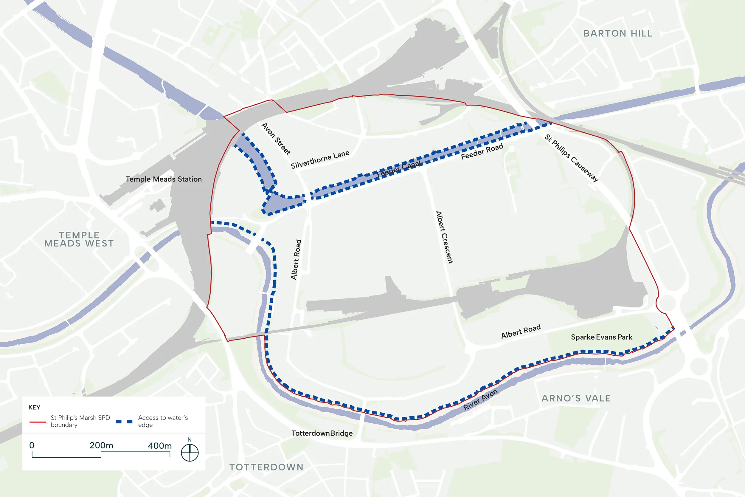
Interaction with Avon Riversides 2100 – formerly Bristol Avon Flood Strategy (SPM 15)
- The SPD identifies an area of impact (covering a 25m offset from the Feeder Canal and 30m buffer from the River Avon) in order to ensure that development within this area does not impact the measures for flood alleviation within the Avon Riversides 2100.
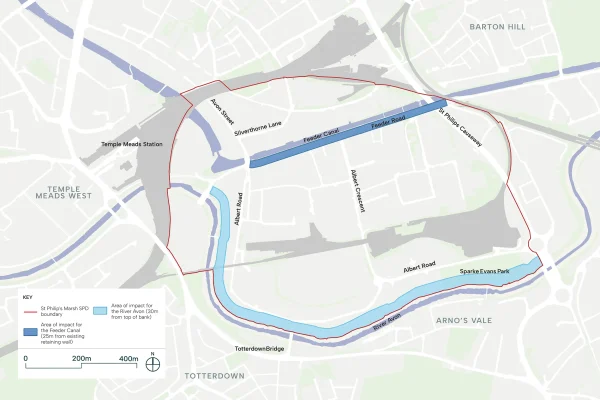
Further information about Avon Riversides 2100 – formerly Bristol Avon Flood Strategy (SPM 15)
Any application within the area of impact identified in the diagram (covering a 25m offset from the Feeder Canal and 30m buffer from the River Avon) must demonstrate its compatibility with and ensure that it does not fetter the Avon Riversides 2100, in line with Policy FR2 of the Bristol Local Plan (2026).
Planning applications adjacent to the area of impact will be expected to demonstrate integration of flood defences and mitigation measures into their design, where appropriate.
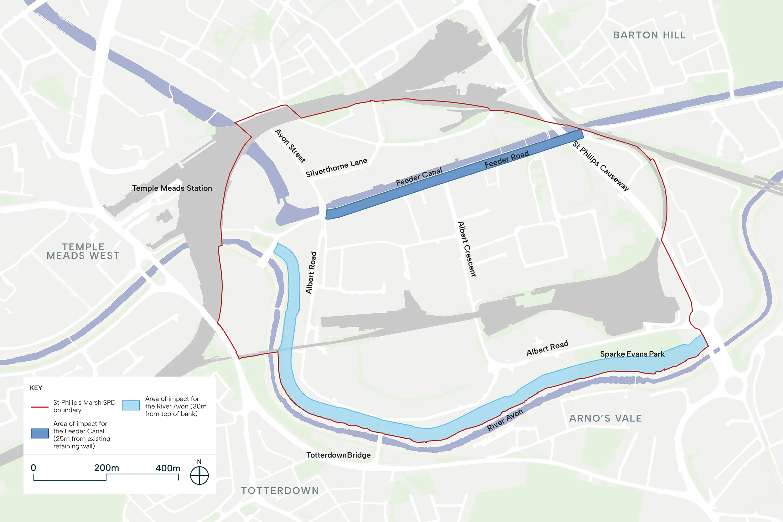
Guidance
A large part of St Philip’s Marsh is vulnerable to flooding from the River Avon. Due to the risk of flooding increasing as a result of climate change, Bristol City Council have established the Avon Riversides 2100 as a long-term plan to better protect homes and businesses. This scheme is critical to unlock the full potential of St Philip’s Marsh and a fully coordinated approach is required to ensure the key additional benefits are provided through these defences, across placemaking, access and ecology.
Policy FR2 of the Bristol Local Plan (2026) requires flood risk from the River Avon to be addressed on a strategic basis consistent with the Avon Riversides 2100. Policy FR2 requires development in an area that benefits from a reduction in flood risk by the future delivery of the Avon Riversides 2100 will be expected to incorporate adequate mitigation measures, respond to residual risk of flooding and facilitate the delivery of future flood defences.
In order to not fetter the implementation of the Avon Riversides 2100, buffer areas have been identified in St Philip’s Marsh in Fig 05.08 in relation to the River Avon and Feeder Canal. Any future planning application for development within the buffer areas will need to demonstrate that it does not impact the Avon Riversides 2100, and complies with Policy FR2 of the Bristol Local Plan (2026).
Acceptable ground floor uses in areas at risk of flooding as set out in the Environment Agency’s latest guidance will be supported.
Along the River Avon and Feeder Canal, flood defence infrastructure should be conceived as place-making opportunity. Both waterways will become defining features of St Philip’s Marsh—high-quality public spaces where flood protection is integrated with landscape design, where possible. However, each waterway will have its own distinct character, responding to its role and context.
On the River Avon, rather than hard engineering solutions, the riverside edge should embrace naturalistic approaches: incorporating generous planting terraces and biodiverse habitat creation that enhance the River Avon experience whilst achieving the required defence level.
The River Avon Corridor must serve multiple purposes. As Bristol’s primary east-west green corridor, it connects St Philip’s Marsh with the wider city. A segregated cycle route and generous pedestrian path will provide safe and attractive infrastructure for commuters, sports enthusiasts and recreational users alike.
Landscape terracing creates visual interest and defines spaces, whilst native planting delivers seasonal colour and supports wildlife. Carefully positioned seating, lighting and wayfinding transform the river walk from functional route into valued destination.
Development parcels adjacent to the River Avon should engage with the waterside through active frontages where possible, creating natural surveillance and animation.
Building design within buffer zones must demonstrate how it enables—rather than constrains—future flood defence delivery.
The Feeder Canal should develop a more urban character. Whilst flood defence principles established along the River Avon also apply here, the design approach should embrace hard landscaping, street furniture and architectural detailing appropriate to an active, urban waterfront.
The Feeder Canal presents an opportunity to create a lively, heritage-rich destination that celebrates Bristol’s industrial past whilst serving contemporary needs. Active ground floor uses, widened pedestrian and cycling routes, street trees and quality public realm will transform the canal edge into an animated urban waterside.
8. Density and heights
All development will be expected to comply with the Urban Living SPD, which defines optimal density as one that balances the efficient and effective use of land with a positive response to context, successful placemaking and liveability. The St Philip’s Marsh SPD principles on building height and density will provide site-specific guidance on where taller buildings may be appropriate, where higher densities are encouraged, and how buildings should respond to climate considerations.
Density (SPM 19)
- Residential development will be required to meet the minimum requirement of 200 dwellings per hectare in line with the Bristol Local Plan (2026) unless it is demonstrated that lower density development is necessary to safeguard assets and character of the area.
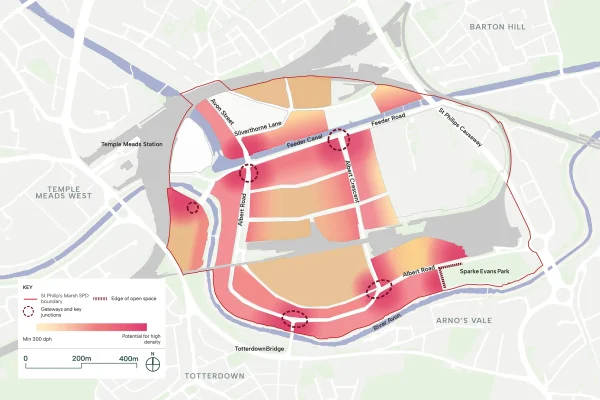
Further information about Density (SPM 19)
Residential development should be delivered in line with the minimum requirement of 200 dwellings per hectare set out in Policy UL2 of the Bristol Local Plan (2026) unless it is demonstrated that lower density development is necessary to safeguard assets and character of the area.
Low density development, such as townhouses, will be considered on their own merits. In these instances, applications should demonstrate that low density development is essential in line with Policy UL2 of the Bristol Local Plan (2026).
Guidance
St Philip’s Marsh will develop as a distinctive, inclusive neighbourhood, that is known for its variety in choice and offer. The density should contribute to the delivery of an inclusive and diverse neighbourhood that attracts diverse households.
St Philip’s Marsh will deliver a diverse, walkable neighbourhood where a rich mix of building typologies creates varied streetscapes and housing types for different household needs.
Policy UL1 of the Bristol Local Plan (2026) states that proposals should develop land to its optimum density. Policy UL2 sets a minimum density target for Bristol City Centre, where St Philip’s Marsh is located, at 200 dwellings per hectare.
The density strategy responds to location, accessibility and relationship to key open spaces.
All development will be expected to comply with the Urban Living SPD, which defines optimal density as one that balances the efficient and effective use of land with a positive response to context, successful placemaking and liveability. Schemes which propose significantly high densities will require early engagement and a more collaborative approach with the Local Planning Authority to ensure all urban living principles are successfully addressed and that the proposal delivers high-quality development that responds positively to its context.
All building typologies should contribute to creating human-scaled streets that are comfortable, safe and inviting for pedestrians. Development should respond to street character and hierarchy, with building heights, frontages and massing designed to create well-defined street edges that foster social interaction at ground level.
The same density can be achieved through diverse building forms, each offering different urban design qualities and housing types.
Building typologies may include:
- Perimeter Block Typologies: Traditional courtyard arrangements that provide excellent street definition whilst maximising dual-aspect flats and communal outdoor space, creating intimate semi-private courtyards for residents. North-facing single aspect units should be avoided. For perimeter blocks with north-south orientation, dual aspect units are strongly encouraged to ensure adequate daylight and sunlight provision. Single aspect units may be acceptable where they face east or west, provided they meet daylight and space standards.
- Point Block Configurations: Taller, slender buildings that minimise ground coverage whilst achieving density through height, offering long-distance views for residents and creating landmark buildings within the neighbourhood.
- Townhouses and Mews Houses: Lower-rise family homes with direct street access, providing ground-level living and outdoor space suitable for families with children.
- Mixed Typology Approaches: Combinations of building forms within a single plot, such as perimeter blocks with corner towers, townhouses alongside mid-rise apartments, or mews houses backing onto courtyard blocks. This approach delivers both houses and flats within the same development, supporting diverse communities and efficient use of land whilst maintaining walkable, human-scale environments.
The combination of building typologies within plots is actively encouraged to promote visual interest, accommodate diverse household sizes, and create land-efficient development that supports shorter walking distances between homes and amenities.
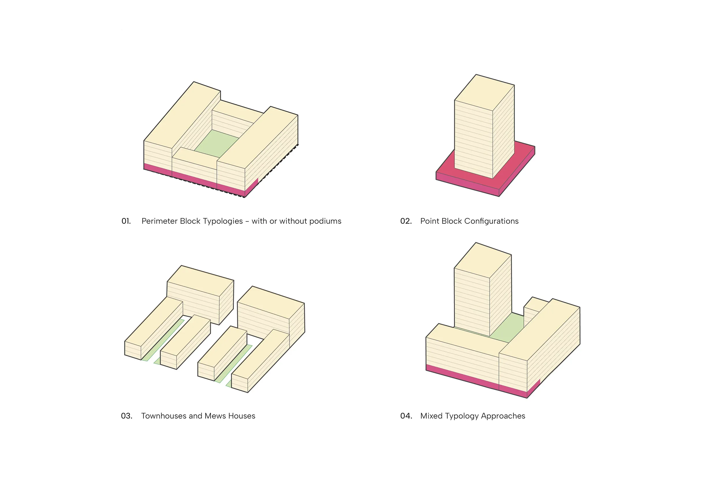
Heights, massing and key views (SPM 20)
- All development will be required to ensure variety and dynamic skylines in line with the relevant character area.
- Landmark buildings at key locations, such as gateways, main street junctions and adjacent to principal open spaces, will be supported.
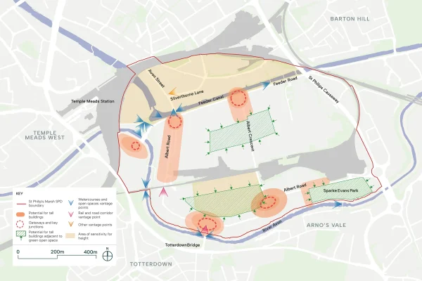
Further information about Heights, massing and key views (SPM 20)
All development will be required to ensure varied and dynamic skylines across the SPD boundary, in line with the relevant character area.
Tall buildings are defined as those of 30 metres of more (equivalent to 10 storeys), in line with Policy DC2 of the Bristol Local Plan (2026), and, subject to appropriate design and setting. They will be considered acceptable in the locations identified in the diagram below.
Strategic placement of landmark buildings at key nodes, such as gateways, main street junctions and adjacent to principle open spaces, will be supported which provide essential wayfinding.
All development must be proportionate in scale to the width of streets and public spaces, and consider impacts on residential amenity. Stepped massing will be encouraged which respects the street scene.
Development for tall buildings will be expected to consider their impact on the significance of nearby heritage assets and their setting, along with impact on retained buildings within the SPD boundary.
All development must also consider key views through out the site.

Guidance
Development in St Philip’s Marsh should prioritise human-scaled development with selective use of taller buildings as wayfinding landmarks and to frame open spaces.
Policy DC2 of the Bristol Local Plan (2026) states that in locations for the most intensive forms of development in Bristol, including St Philip’s Marsh, tall buildings may be appropriate where they would contribute positively to the character and function of the urban environment.
Moderate building heights are encouraged as they create pedestrian-friendly streetscapes where users tend to feel more comfortable, as this scale allows for appropriate daylight penetration to the streetscape and reduces the wind tunnelling effects that high-rise development could create in this exposed riverside location.
However, sensitively-placed height allows for the delivery of the residential provision required to respond to Bristol’s housing needs whilst bringing sufficient critical mass of people to the area to ensure the success of retail and community infrastructure.
Tall building should be strategically placed, as they can provide landmarks at key nodes—such as gateways, main street junctions, and adjacent to principal open spaces like Sparke Evans Park and Canal Square—offering essential wayfinding.
Development should offer a varied roofline that creates an engaging experience and distinctive skyline for St Philip’s Marsh.
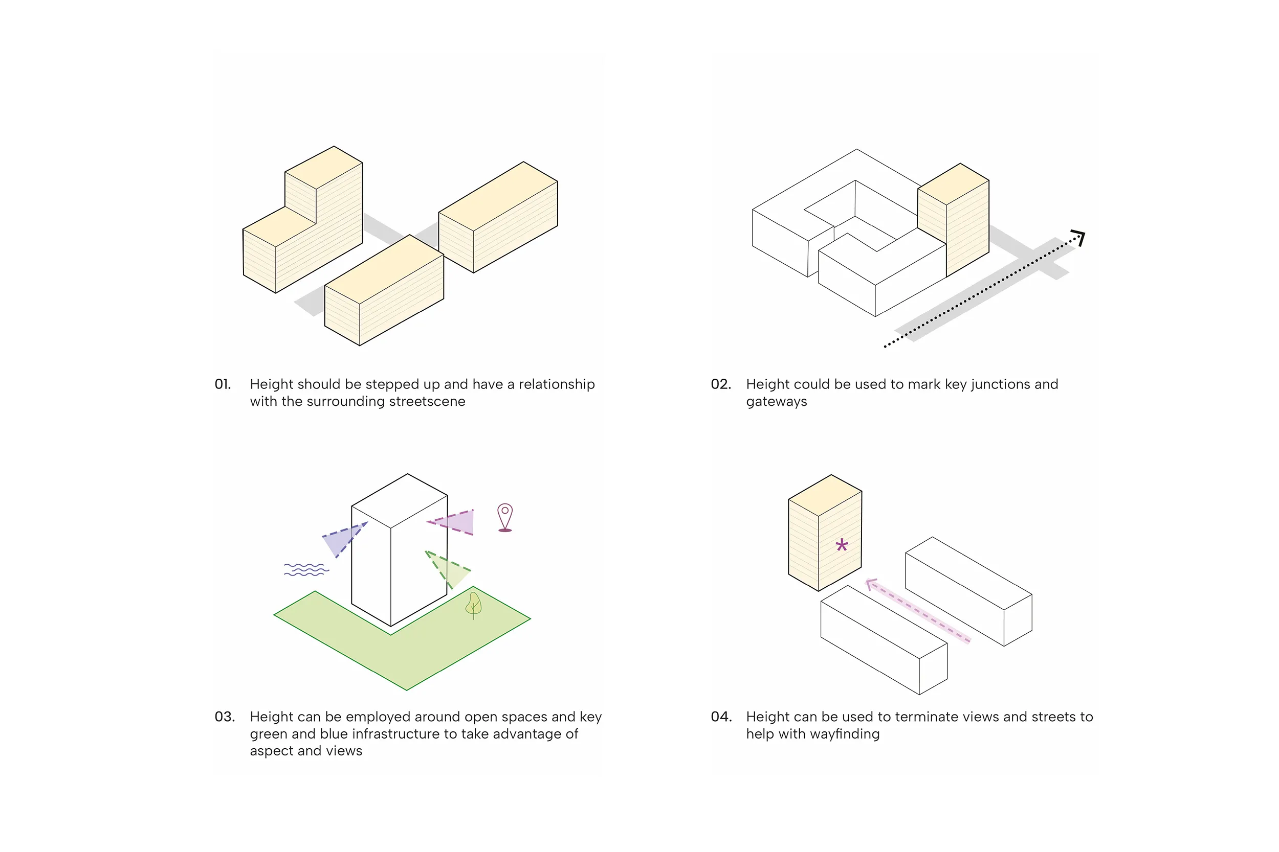
Roof Treatment (SPM 21)
A variety of roof types and finishes will be supported in St Philip’s Marsh. Blue and green roofs and solar panels will be encouraged.
Daylight, Sunlight and Microclimate (SPM 22)
- The SPD will encourage dual aspect homes and sufficient daylight and sunlight levels that is appropriate for its context.
- Tall development will be required to ensure it does not harmfully affect wind deflection or other microclimate impacts.
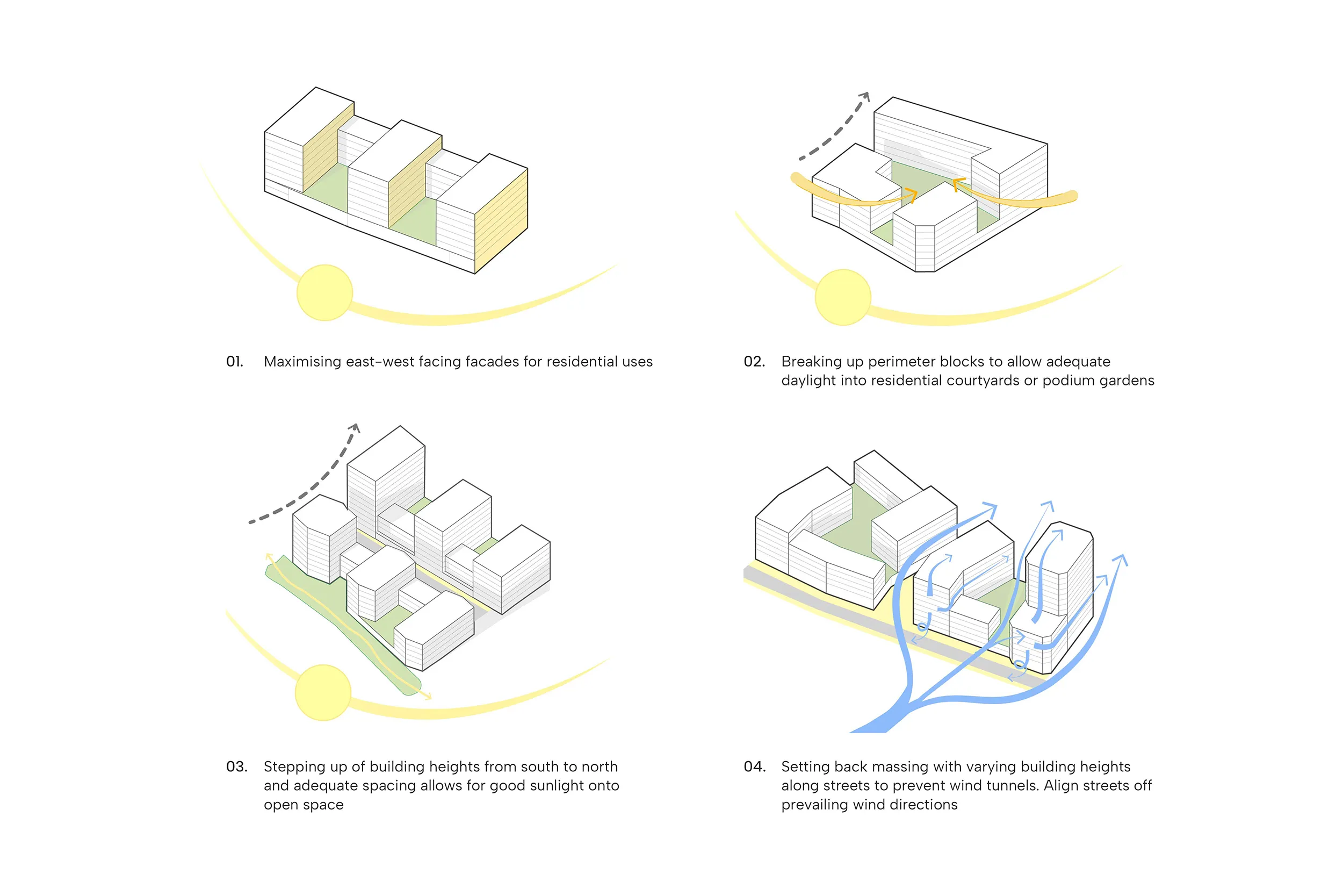
9. Access and movement
All streets in St Philip’s Marsh must comply with Bristol City Council (BCC) Transport Development Guidance and enable safe, comfortable movement for all users, regardless of age or physical ability. The St Philip’s Marsh SPD principles related to access and movement set the requirements for street hierarchy, strategic and public transport and parking.
Movement Strategy (SPM 16)
- Pedestrian amenity has been a key consideration and the proposals include wide footways, segregated cycle routes and a number of routes where pedestrians will have priority on key desire lines.
- The key vehicular and pedestrian routes include:
- Feeder Road will serve as a key east-west connector.
- Albert Crescent will be a Primary Pedestrian route which serves neighbourhood functions and connects the North West Character Area to the South Character Area via an existing underpass under the Network Rail Depot.
- River Walk runs along the River Avon and is a riverside pedestrian route which supports its recreational character as a linear park and leisure destination.
- Main vehicular routes will be focused along Albert Road and in the North East Character Area to support the employment and industrial uses.
- Albert Road will be a Primary Route for vehicles and serve as the primary north-south connector.
- Chapel Street is a Secondary Route for vehicles and provides an east-west connection parallel to Feeder Road.
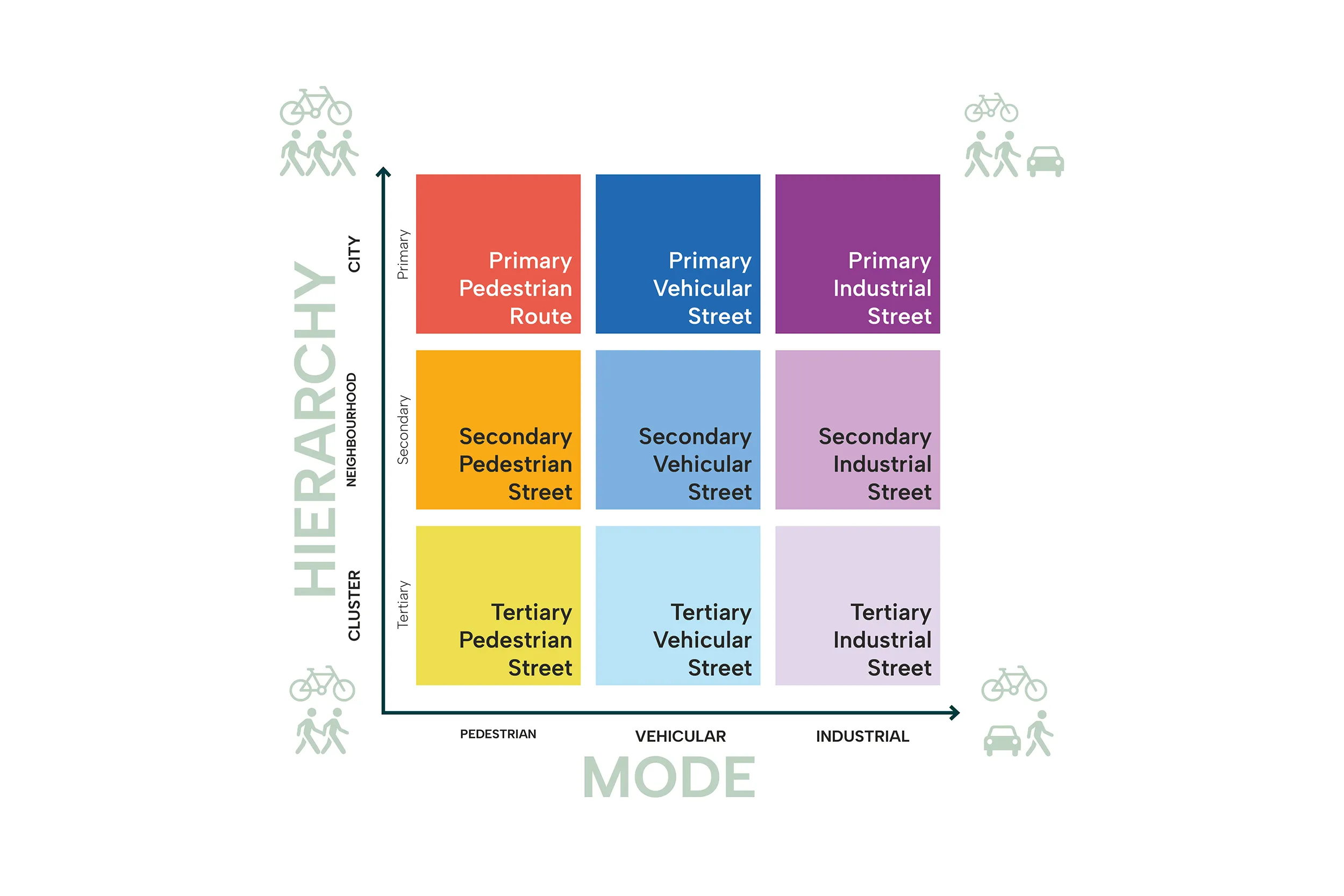
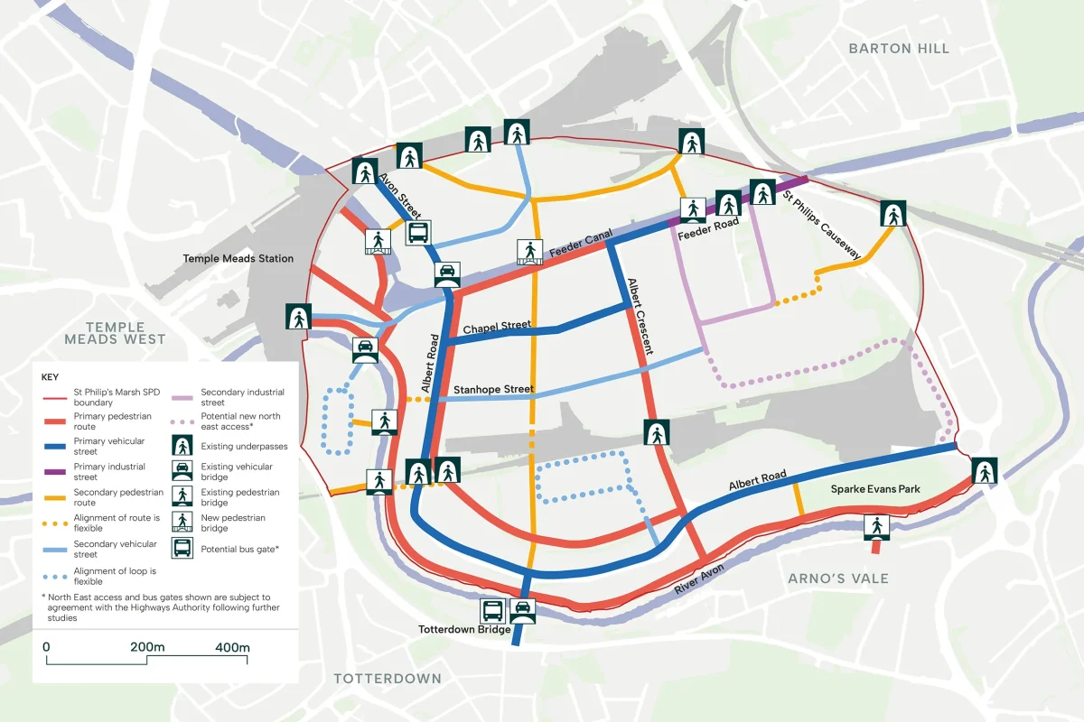
The street network is organised into a clear hierarchy of primary, secondary and tertiary streets, each with distinct roles and characteristics. Streets are further categorised as pedestrian, vehicular or industrial, reflecting significant character differences based on transport modes and adjacent land uses.
The streetscape design will follow Bristol City Council’s Transport Development Management Guide. The St Philip’s Marsh Street Matrix provides additional guidance, identifying key components and minimum dimensions for each street typology. Dimensions can be adapted to suit specific site conditions, such as additional spill-out space for adjacent uses, privacy buffers or local width constraints.
The following principles establish the design approach for all streets within St Philip’s Marsh:
- Providing Choice: From routes designed for city-wide movement to intimate streets designed for daily life and social interaction.
- Pedestrian Priority: Pedestrians take priority across all streets.
- Cycling Safety: Segregated cycle lanes on primary routes, with other streets designed for safe cycling within the general traffic flow or on shared surfaces.
- Inclusive Design: Streets that are accessible and welcoming for all users.
- Green Infrastructure: Generous landscaping with integrated Sustainable Urban Drainage Systems (SuDS), contributing to biodiversity and climate resilience.
- Operational Flexibility: Street design that accommodates changing needs, such as loading bays, parking and drop-off areas.
Primary streets structure the site and connect St Philip’s Marsh to wider Bristol, delivering high site-wide accessibility. These are the most significant movement corridors within the masterplan, designed to accommodate the greatest intensity of movement and activity. They can act as a focus for retail and other services. Where vehicular, primary streets are designed to accommodate public transport.
Secondary streets support local connections within St Philip’s Marsh, linking primary streets to key open spaces, community infrastructure and providing access into residential and mixed-use neighbourhoods. These streets carry moderate levels of movement and provide the framework for local journeys.
Tertiary streets are quieter routes that enable a permeable, walkable neighbourhood. These streets prioritise place over movement, creating intimate, human-scale environments that support social interaction, health and wellbeing. They provide access to individual homes and plots.
Further information about Movement Strategy (SPM 16)
St Philip’s Marsh is expected to be a low-traffic, walkable neighbourhood where vehicular movement is minimised, and pedestrians and cyclists are prioritised through the movement network.
All development within the SPD area must deliver a comprehensive, legible and well-defined movement network which enables local movement routes and integrates with existing routes outside of the SPD boundary where possible.
The movement network must be accessible and encourage movement across multiple modes, and must be mindful of existing utilities and trees.
The Primary and Secondary routes set out in diagram below will be expected to be delivered in order to provide north-south and east-west connections through the SPD area.
All Primary and Secondary routes identified on must comply with the suggested street typologies unless it can be demonstrated it is not feasible.
Feeder Road will be expected to serve as a key east-west connector and form the North West Character Area’s main street. Feeder Road will be expected to be partly pedestrianised to prevent through traffic and create a high quality public realm.
Albert Crescent is a Primary Pedestrian route which serves neighbourhood functions and connects the North West Character Area to the South Character Area via an existing underpass under the Network Rail Depot.
River Walk runs along the River Avon and is a riverside pedestrian route which supports its recreational character as a linear park and leisure destination.
Whilst vehicular access must be restricted in the pedestrian routes, design of the movement network must ensure necessary vehicular access for emergency services, delivery and servicing, and essential services and utilities.
Main vehicular routes will be focused along Albert Road and in the North East Character Area to support the employment and industrial uses.
Albert Road will be a Primary Route for vehicles and serve as the primary north-south connector.
Chapel Street is a Secondary Route for vehicles and provides an east-west connection parallel to Feeder Road.
Along Primary and Secondary vehicular routes, pedestrians and cyclists should remain priority. These routes should feature safe and segregated pedestrian pavements and cycle lanes.
Tertiary routes, which form a network of quieter residential streets, can be implemented more flexibly and will be supported where they align with the proposed Primary and Secondary routes. Tertiary Streets should consider the street typologies illustrated in proposed illustrative sections, alongside the illustrative example of how a tertiary network could be delivered as depicted in the illustrative masterplan.
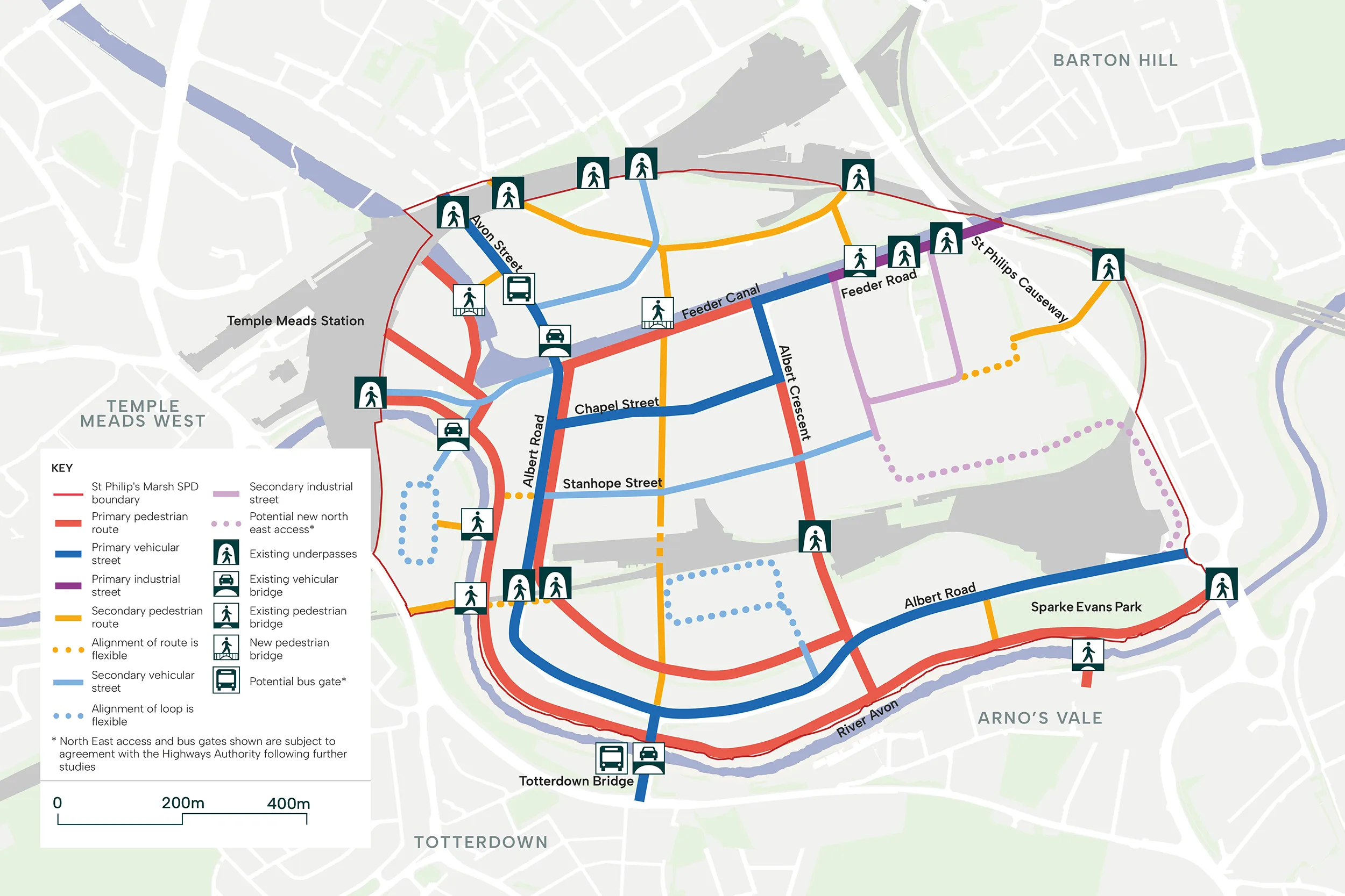
Guidance
The street network for St Philip’s Marsh must enable safe, comfortable movement for all users, regardless of age or physical ability. Streets function as more than transport corridors—they are public spaces that support healthy lifestyles, encourage active travel and provide settings for community life.
Policy T1 of the Bristol Local Plan (2026) aims to minimise the need to travel, especially by private vehicle, and maximise opportunities for walking, cycling and use of public transport. The policy seeks the creation of places and streets shaped by the needs of pedestrians, cyclists and public transport users to produce a liveable environment.
The streets of St Philip’s Marsh will be designed as attractive, multifunctional spaces that integrate sustainable urban drainage, generous soft landscaping and substantial tree canopy. This approach not only creates pleasant, walkable environments but actively mitigates the urban heat island effect, contributing to climate resilience.
All streets must comply with BCC Transport Development Guidance.
Street alignments may vary slightly from indicative plans, provided they maintain comprehensive connectivity throughout the movement network and deliver the street hierarchy and typologies established in this SPD.
Development within the SPD should also appropriately consider micromobility in the design of public realm.
To read more about different types of streets
Pedestrian
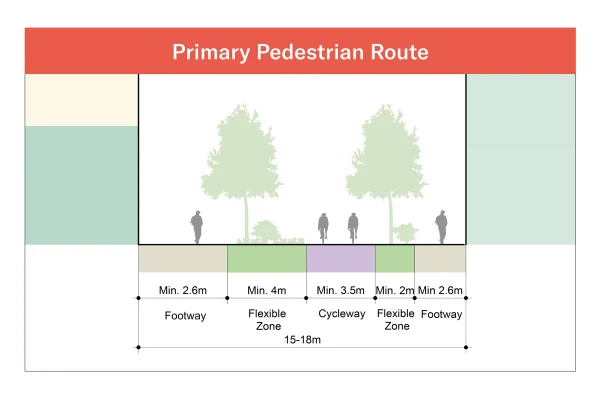
Primary pedestrian route
- Designed for high pedestrian footfall with segregated cycleway of minimum 3.5m.
- Vehicular access restricted to emergency and servicing vehicles only
- Footways of minimum 2.6m provided on both sides.
- Flexible zones accommodate trees, seating, SuDS, spill-out space for adjacent commercial uses, loading bays or parking.
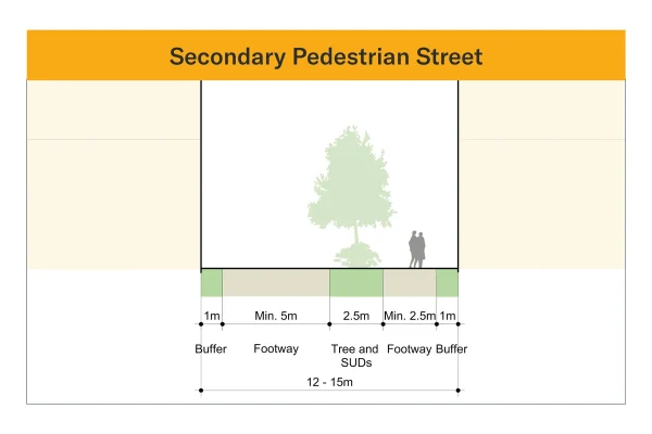
Secondary pedestrian street
- Designed to prioritise walking and cycling, with vehicular access restricted to emergency and servicing vehicles only.
- Minimum 2.5m footways provided; shared surface width of 5.0m where emergency vehicle access is required.
- Cycling accommodated within the shared surface.
- Flexible zones accommodate trees, seating and SuDS. Privacy buffers provided along residential ground floors where required.
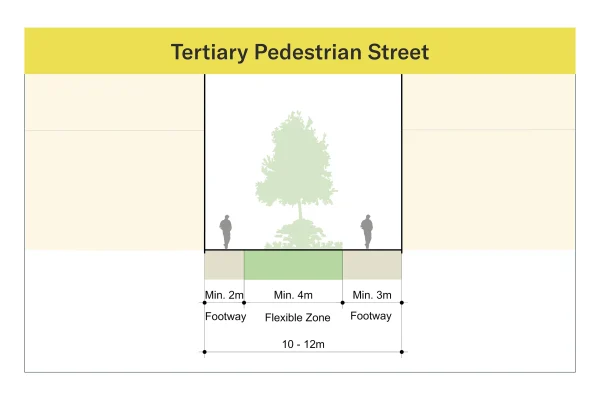
Tertiary Pedestrian Street
- Designed for walking and cycling only, with no vehicular access.
- Shared pedestrian and cycle path of minimum 3.0m with pedestrian priority. Footways of minimum 2.0m.
- Flexible zones accommodate trees, seating and SuDS. Privacy buffers provided along residential ground floors where required.
Vehicular
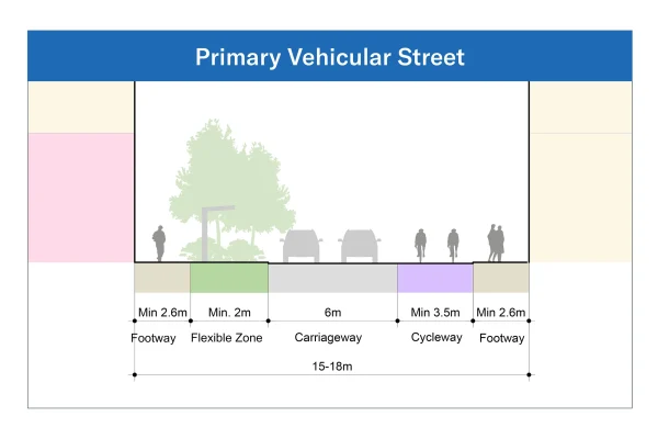
Primary Vehicular Street
- Designed to take through traffic and public transport, with design speed of 20mph.
- Carriageway widths of minimum 6.0m, increasing to 6.2m where bus routes are accommodated.
- Segregated cycleways of minimum 3.5m and footways of minimum 2.6m provided on both sides.
- Flexible zones accommodate trees, seating, SuDS, spill-out space for adjacent commercial uses, loading bays or parking.
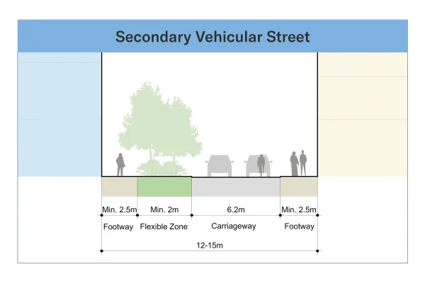
Secondary Vehicular Street
- Designed to provide local distribution, with a design speed of 20mph.
- Carriageway widths of minimum 6.4m to accommodate cyclists safely; where a segregated cycleway is provided, the carriageway can be reduced to 5.0m (no public transport) or 6.2m (bus routes).
- Footways of minimum 2.5m required on both sides.
- Flexible zones accommodate trees, seating, SuDS or parking.
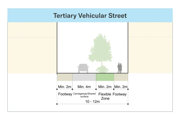
Tertiary Vehicular Street
- Designed to provide access to plots, with a design speed of 20mph. If it is a shared surface, speed must be limited to 5mph.
- One-way carriageway widths of minimum 4.0m with localised narrowing where appropriate.
- Cycling generally accommodated on-carriageway with general traffic and footways of minimum 2.0m required on both sides.
- Flexible zones accommodate trees, seating and SuDS. Privacy buffers provided along residential ground floors where required.
Industrial
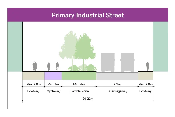
Primary Industrial Street
- Designed to accommodate heavy goods vehicles, with design speed of 20mph
- Carriageway widths of minimum 7.3m to allow two-way HGV movement, with localised widening where swept paths require
- Segregated cycleways of minimum 3.0m, and footways of minimum 2.6m provided on both sides
- Flexible zones accommodate trees, seating, SuDS, loading bays or parking
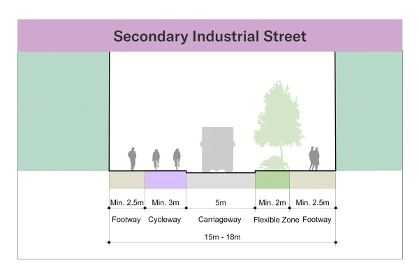
Secondary Industrial Street
- Designed to accommodate heavy goods vehicles, with a design speed of 20mph
- One-way carriageway widths of minimum 4.0m. Two-way can be provided where required
- Segregated cycleways of minimum 3.0m and footways of minimum 2.5m are required
- Flexible zones accommodate trees, seating, SuDS, loading bays or parking
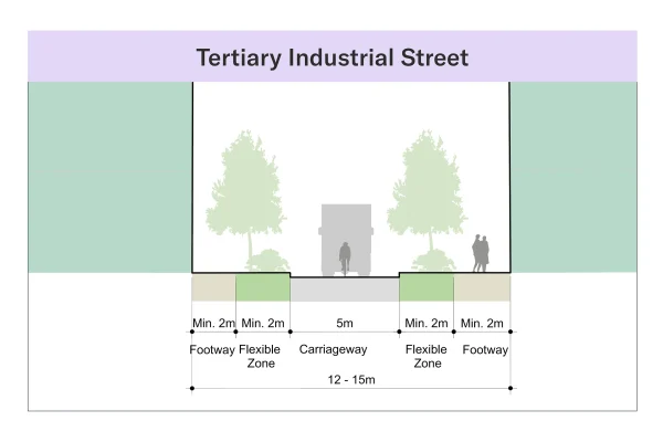
Tertiary Industrial Street
- Designed to accommodate heavy goods vehicles, with a design speed of 20mph.
- One-way carriageway widths of minimum 4.0m to accommodate HGV movement.
- Cycling generally accommodated on-carriageway and footways of minimum 2.0m are required on both sides
- Flexible zones accommodate trees, seating, SuDS or parking
To find out more about four alternatives for access to the North East
Options for Potential New North East St Philip’s Marsh Access
The Bristol Local Plan requires the consolidation and intensification of industrial activity within St Philip’s Marsh, ensuring that this area continues to contribute to the city’s employment land supply whilst accommodating new homes and community uses.
The successful coexistence of industrial and residential uses requires careful management of industrial servicing and vehicle movements.
To inform the development of this SPD, work is underway to explore options for a dedicated access route that could serve industrial uses in North East St Philip’s Marsh, whilst minimising impact on residential areas. A number of potential options are currently being considered.
A dedicated industrial access route will:
- Remove industrial traffic from residential and mixed-use streets.
- Avoid traffic concentration within residential areas.
- Provide efficient and direct access to industrial facilities.
- Enable the creation of a pedestrian-priority, slow-movement neighbourhood.
- Support improved air quality, reduced noise and enhanced residential amenity.
- Create a safer, more inviting environment for pedestrians and cyclists within the residential and mixed-use areas.
Four options have been studied and are set out below.
- All the options are subject to agreement with the Highways Authority following further studies.
- Further technical work, modelling and evidence gathering are underway.
- Designs will be refined following ongoing discussions.
Option A: Access via a new bridge
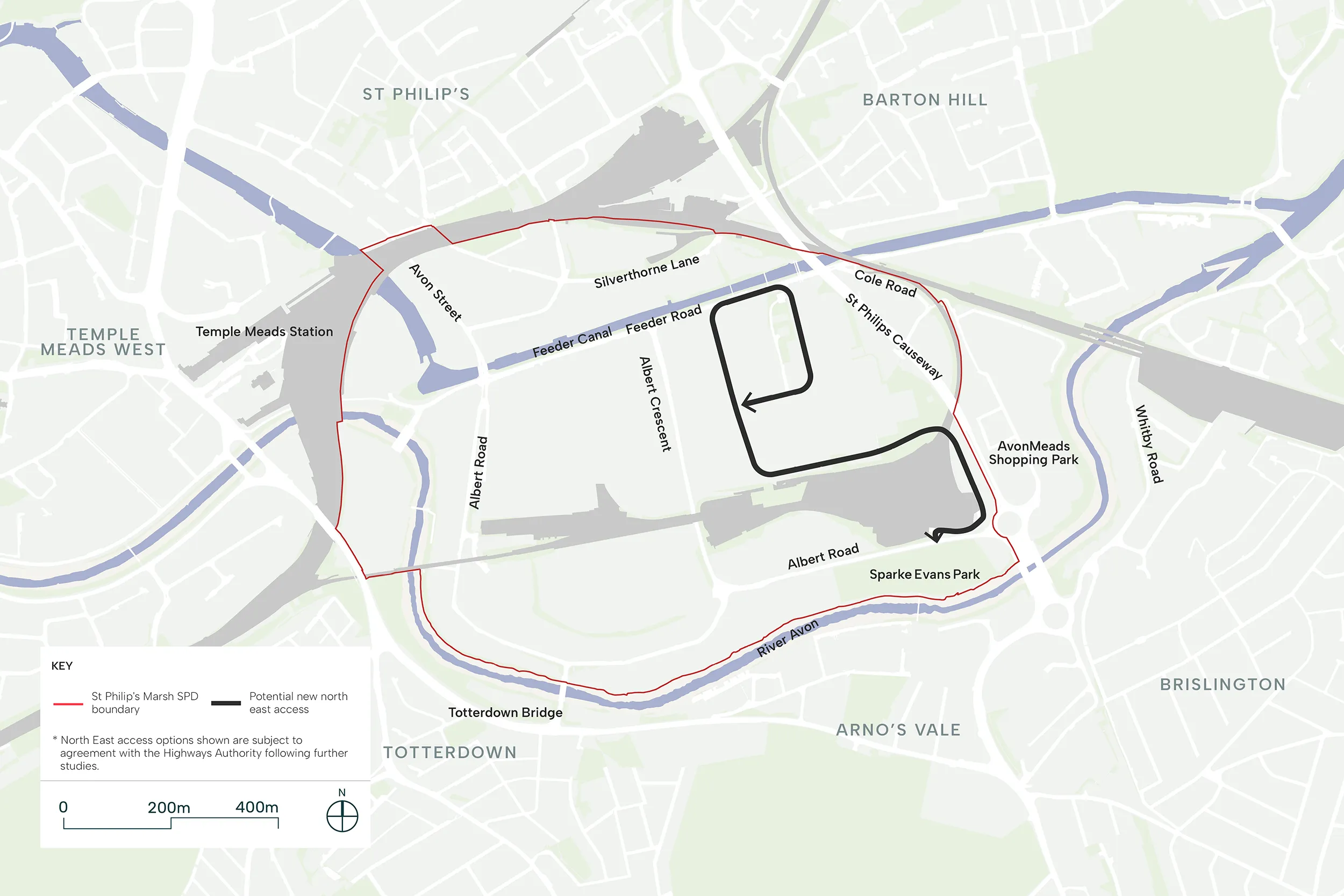
- Vehicles to come off St Philips Causeway roundabout onto Albert Road and turn into the existing Network Rail and KFC access road. Vehicles will then head north onto a vehicular bridge over the depot then landing on the north side of the depot in North East St Philip’s Marsh.
- Existing access to the KFC to be reconfigured either by creating a new junction off St Philips Causeway roundabout or improving the junction at Albert Road.
Option B: Access via Whitby Road
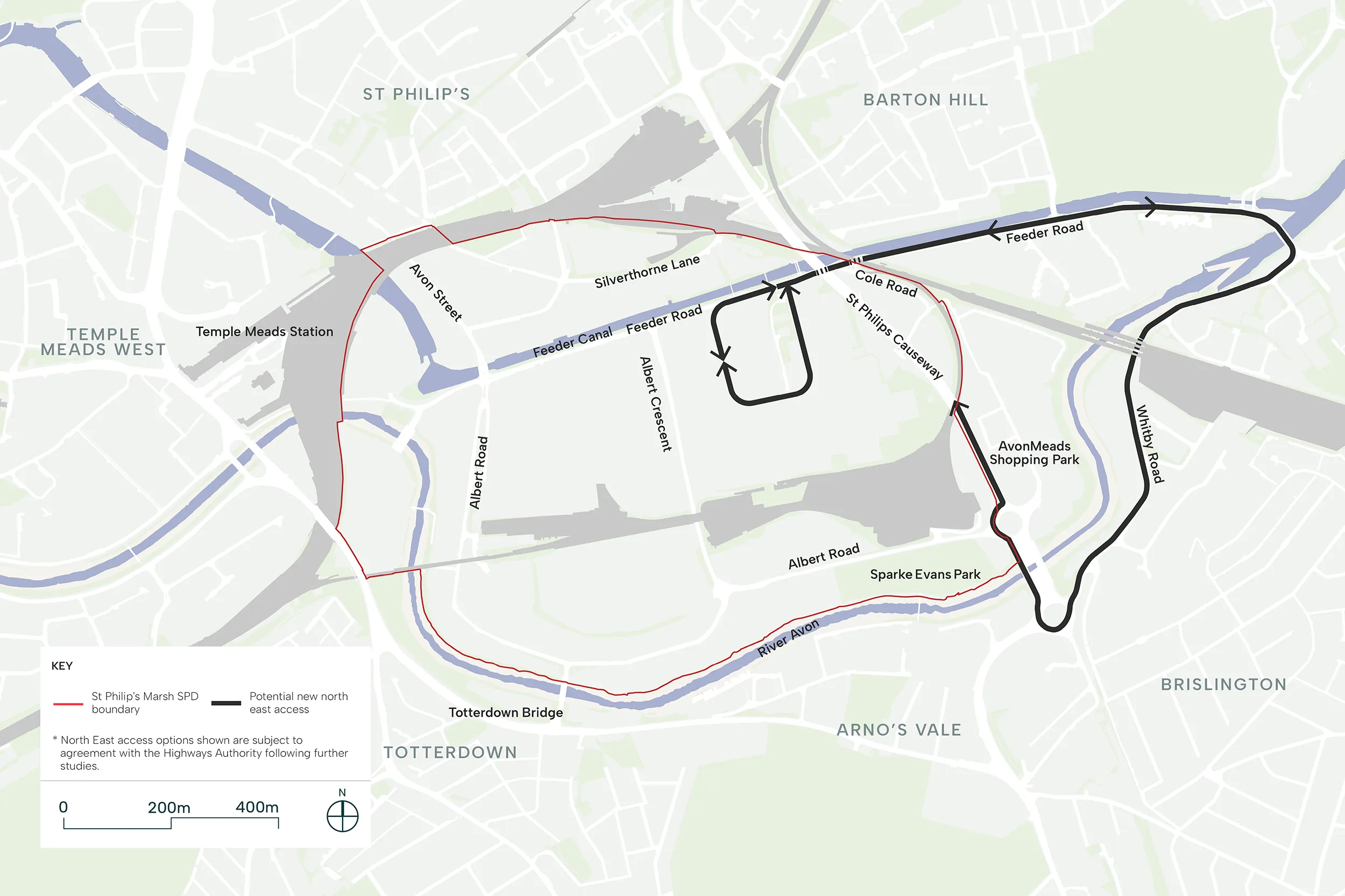
- Industrial vehicles will head south off St Philips Causeway roundabout then east onto Whitby Road, crossing Brislington Bridge then travelling west on Feeder Road to access North East St Philip’s Marsh.
- Whitby Road will need to be lowered and widened within the mainline railway underpass on Whitby Road. The underpass will also require substantial structural work to widen it to safely accommodate industrial vehicles and safe pedestrian provision.
- Whitby Road / Feeder Road junction and Brislington Bridge will need to be upgraded.
Option C: Access via Cole Road
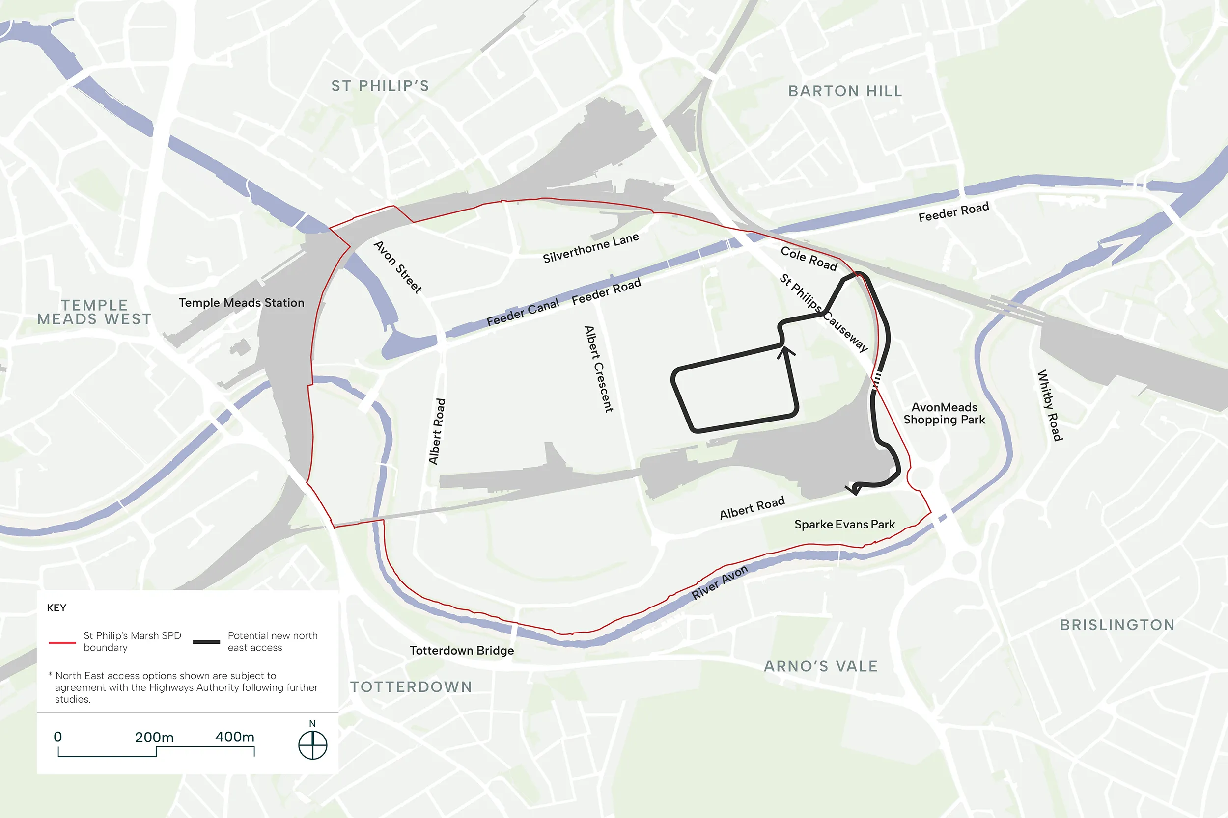
- Vehicles will come off St Philips Causeway roundabout onto Albert Road and turn into the existing Network Rail and KFC access road then continue under St Philips Causeway onto the edge of Avonmeads Shopping Park, entering North East St Philip’s Marsh from the east through an underpass beneath the railway line onto Cole Road.
- Cole Road to be lowered and widened within the railway underpass. Substantial structural works required to widen the underpass to safely accommodate industrial vehicles and safe pedestrian provision.
- Existing access to the KFC to be reconfigured either by creating a new junction off St Philips Causeway roundabout or improving the junction at Albert Road.
- Final route alignment to be studied further.
Option D: Access via Albert Crescent
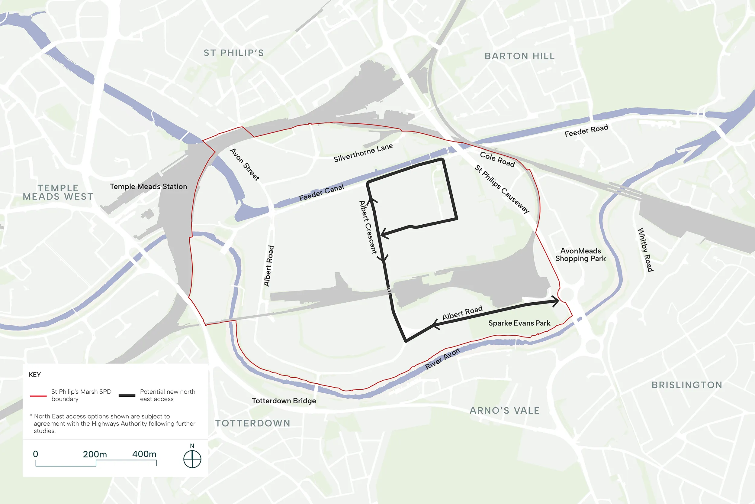
- Vehicles to come off St Philips Causeway roundabout onto Albert Road and head north onto Albert Crescent, then pass through the underpass under the railway depot and continue on until Feeder Road where vehicles will head east into North East St Philip’s Marsh.
- Albert Crescent to be lowered and widened. The railway depot underpass will require substantial structural works to be widened to safely accommodate industrial vehicles and safe pedestrian and cycling provision.
To find out more about potential transformation of Feeder Promenade, Albert Road/ Victoria Street and Riverside
Feeder Promenade
The Feeder Promenade is a pedestrian-priority route that anchors the district centre, creating a vibrant waterside destination along the Feeder Canal. This promenade establishes St Philip’s Marsh’s primary retail and leisure frontage, combining active ground floor uses with generous public realm.
Key Characteristics:
- Pedestrian Priority: A wide pedestrian corridor provides ample space for walking, window shopping and socialising, enabling the promenade to function as the heart of the district centre.
- Cycling Provision: A 4m wide segregated cycle lane ensures safe, comfortable cycling separated from pedestrian flows, supporting commuter and recreational cycling along this key east-west route.
- Waterside Landscape: Landscape provision is concentrated along the canal frontage, creating a generous green corridor that enhances biodiversity, provides amenity and celebrates the heritage waterway. Planting, seating and lighting establish the canal edge as an attractive, usable space. Lighting design should balance the needs of wildlife and habitat protection with safety and security requirements.
- Urban Square: The promenade widens at a strategic location to a create a public square where retail services, food and beverage uses and community facilities concentrate. This square functions as focal point for social gathering, events and outdoor dining.
- Active Frontages: Development along the promenade must provide active ground floor uses, frequent entrances and opportunities for spill-out space, creating natural surveillance and animation throughout the day and evening.
- Integrated Flood Defence: The promenade integrates flood defence infrastructure within high-quality landscape design, achieving the required defence level whilst maintaining an attractive, accessible waterfront environment.
- Accessibility: The design of the promenade and public spaces must consider the needs of all users, including disabled people and reduced mobility. Level surfaces, appropriate gradients, tactile paving, resting places and clear wayfinding should be incorporated to ensure the promenade is inclusive and welcoming for everyone.
- Moorings and Boat Community: Towards the eastern end of the promenade, applicants should explore the feasibility of canal moorings and associated facilities to support the boat community. This may include access to water, waste disposal and electrical services, as well as appropriately designed access points between the tow path and water.
Albert Road and Victoria Street
Albert Road serves as the primary north-south connector through St Philip’s Marsh, linking the northwest and southeast clusters and connecting to wider Bristol. With the Network Rail Depot creating a significant barrier to permeability, Albert Road plays a crucial role in unifying the neighbourhood and establishing safe connections.
The street is reimagined in two distinct sections, responding to different site conditions and opportunities.
Northern Section
- Dual Routes: Albert Road is enhanced with widened pedestrian pathways and a reduced carriageway, prioritising walking whilst maintaining vehicular access. Victoria Street and the adjacent surface car park are transformed into a linear park, creating a generous green corridor that forms part of the site’s green network.
- Segregated Cycling: A 3.5m wide segregated cycle lane runs through the Victoria Street linear park, providing a safe, attractive north-south cycling route.
- Landscape Character: The linear park delivers substantial landscaping. This green corridor provides biodiversity benefits, recreational space and contributes to climate resilience whilst enabling safe active travel.
Southern Section
Vehicular Priority: South of the Network Rail Depot, after Victoria Street terminates, Albert Road functions as a primary vehicular street.
Integrated Cycling: Due to proximity to Albert Gardens and the River Avon main cycling corridor, no segregated cycle lane is provided. Instead, the carriageway width and traffic speeds are designed to enable safe cycling within the general traffic flow, with cyclists sharing the road.
Albert Crescent
Alongside Albert Road, Albert Crescent serves as a primary north-south connection within St Philip’s Marsh. Its central location makes it instrumental for movement throughout the site, connecting all clusters and integrating different uses from industrial to residential areas. Albert Crescent is reimagined in two distinct sections, each responding to its location and functional requirements.
Northern Section: Secondary Vehicular Street (North of Chapel Street)
- Vehicular and Public Transport: Albert Crescent functions as a secondary vehicular street, accommodating general traffic and enabling continuity of the bus route to ensure public transport serves the district centre and wider neighbourhood.
- Segregated Cycling: A 3.5m segregated cycle lane provides safe north-south cycling, separated from vehicular traffic and pedestrian flows.
- Tree Retention: Existing Tree Protection Order (TPO) trees are retained, preserving established character and contributing to the street’s green infrastructure.
- Accessible Connections: Drop-off areas for people with reduced mobility are provided near the Feeder Promenade, ensuring the district centre remains accessible to all users.
Southern Section: Primary Pedestrian Street (South of Chapel Street)
- Pedestrian Priority: Albert Crescent transforms into a main pedestrian street, creating a vital connection between the northern and southern clusters. This car-free environment prioritises walking, social interaction and community life.
- Wide Pedestrian Corridor: Generous pedestrian pathways provide ample space for movement, lingering and social activity, establishing the street as a comfortable, people-focused environment.
- Segregated Cycling: A 3.5m wide segregated cycle lane maintains safe north-south cycling connectivity.
- Generous Landscaping: Substantial landscape areas with integrated Sustainable Urban Drainage Systems (SuDS) create an attractive, climate-resilient street environment.
Riverside
The River Avon Walk along the southern boundary represents both a significant opportunity and defining feature for St Philip’s Marsh. Currently a narrow footpath with blank building façades backing onto it, the corridor is transformed into an ecological river walk that serves as Bristol’s primary east-west green corridor.
Key Characteristics:
- Wide Pedestrian Corridor: A generous pedestrian footpath provides comfortable space for walking, running and recreational activity, creating a place to pause, relax and enjoy a riverside experience that brings people closer to nature.
- Segregated Cycling: A 4m-wide segregated cycle lane provides safe, continuous east-west cycling connectivity, separated from pedestrian flows. This supports both commuter and recreational cycling. The cycle lane will have to be 4.5m wide to accommodate a balustrade if the cycle lane abuts the river edge.
- Ecological Enhancement: Substantial landscape areas create an ecological corridor that restores riverside habitats and supports biodiversity. Native planting, varied vegetation structure and habitat features enhance ecological value whilst providing seasonal interest and visual amenity.
- Integrated Flood Defence: Landscape terracing transitions between development and the river, achieving the required flood defence level through naturalistic design.
- Building Development: Development parcels along the River Avon engage with the waterside through active frontages, habitable rooms and entrances facing the corridor. This creates natural surveillance, animation and establishes a strong relationship between buildings and the river walk. Open space within these plots will be connected to the River Avon to create expansions in the ecological corridor.
- Variable Width: The corridor width varies along its length. Some sections offer a wider ecological corridor with generous landscape provision, whilst others tighten to create more intimate, enclosed experiences. This variation creates a rich, varied journey along the river.
Strategic and Public Transport (SPM 17)
- The SPD will require an efficient bus network through St Philip’s Marsh, with bus stops located along Feeder Road, Chapel Street and Albert Road to ensure all residents and workers can access a bus stop within a 5-minute walk.
- The introduction of bus gates in St Philip’s Marsh, such as on Totterdown Bridge and Avon Street, will be supported, subject to it being demonstrated that they do not adversely affect the wider transport network.

Further information about Strategic and Public Transport (SPM 17)
New and existing streets which allow for regular vehicular access (Feeder Road / Chapel Street / Albert Road) will provide key public transport infrastructure for St Philip’s Marsh.
Given access constraints for the site, there are limited opportunities for an efficient bus network to be provided and therefore any proposal which conflicts with the arrangement identified in diagram below must demonstrate an alternative arrangement.
Along the bus route, bus stops must be located along Feeder Road, Chapel Street and Albert Road to ensure all residents and workers can access a bus stop within a 5-minute walk. Bus stops must be positioned near key destinations to make visiting St Philip’s Marsh convenient for people from across Bristol.
The introduction of bus gates will be support in appropriate locations, subject to it being demonstrated that they do not adversely affect the wider transport network.
Public transport infrastructure should seamlessly integrate with the existing public transport network and proposed public realm.
Strategic transport requirements to enable comprehensive development are set out in page 11.
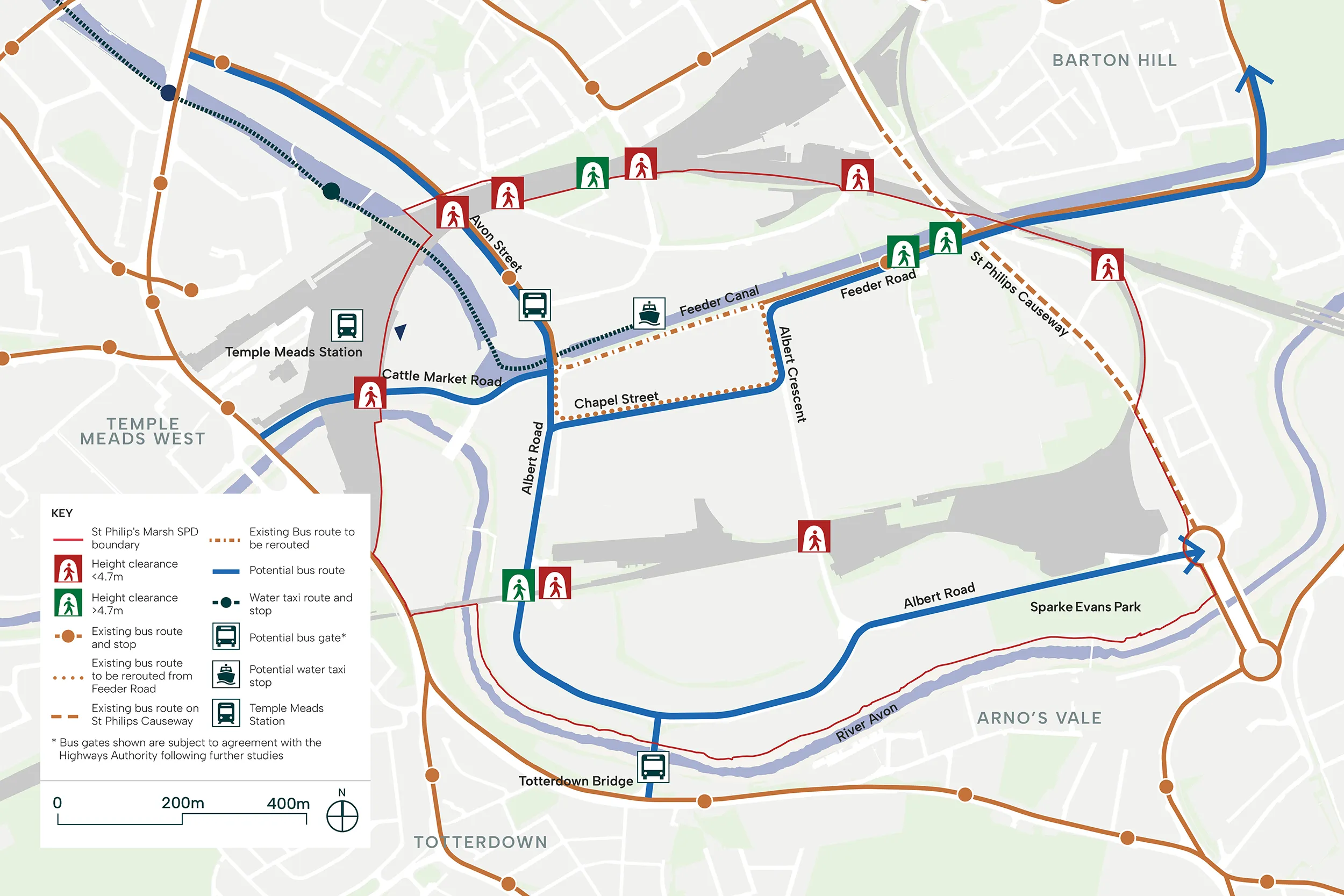
Guidance
Currently, St Philip’s Marsh has limited public transport provision, with only one route servicing the site. The transformation of St Philip’s Marsh into a mixed-use neighbourhood requires substantial enhancement of bus connectivity to ensure the area functions as an accessible, sustainable neighbourhood.
Policy T2 of the Bristol Local Plan supports the delivery of significant improvements to transport infrastructure and sustainable travel measures, including enhancements to public transport infrastructure.
The proposed bus network establishes comprehensive connections through and beyond the masterplan area. The public transport strategy recognises that convenient, reliable bus services are fundamental to creating a car-light neighbourhood. By ensuring comprehensive coverage and high-quality infrastructure, St Philip’s Marsh can establish sustainable travel patterns from the outset, reducing car dependency in the area.
Strategic transport interventions, including potential bus gates at Totterdown Bridge and Avon Street, would ensure buses can move efficiently through the network whilst managing general traffic flows.
Bus stops should be positioned to enable easy interchange with other transport modes, particularly at Temple Meads station and locations with cycle parking and car club facilities.
Parking (SPM 18)
- All development within the SPD boundary must comply with the car parking, accessible parking, EV charging and cycle parking standards set out in Policy T4A of the Bristol Local Plan (2026) and relevant guidance.
- Given the SPD’s central location and existing connectivity, low levels of car parking provision will be supported.
- A mobility hub will be encouraged to serve the employment, commercial and community uses proposed in the North East and North West Character Areas.
- Note: A mobility hub is a location where different transport options — such as bike hire, public transport, car club and private vehicles — come together in one place.
10. Illustrative Masterplan as one potential outcome
The illustrative masterplan below sets out a potential approach for delivering the regeneration of St Philip’s Marsh while meeting the absolute requirements outlined in the SPD.
The map below is interactive. Click on the areas marked with a dot to reveal visualisations of how St Philip’s Marsh could look in the future. Please note that these visuals represent only one possible outcome and are intended to illustrate the potential character of a transformed St Philip’s Marsh.
11. Phasing and infrastructure
Key to the success of comprehensive development is the delivery of physical and social infrastructure which underpin the regeneration of St Philip’s Marsh. As a significant amount of growth is anticipated to come forward in St Philip’s Marsh, it is important to ensure the growth is supported sufficiently, in line with Policy IDC1 of the Bristol Local Plan (2026).
Whilst this section of the SPD does not cover all items which may be sought from qualifying development, it sets out the strategic infrastructure considered required. The infrastructure requirements set out in the list below align with the Local Plan requirements but provides additional supplementary details to allow for the phased delivery of the regeneration area.
Phasing
Given the scale of development envisaged at St Philip’s Marsh, it is anticipated that the regeneration proposals will come forward in a phased manner and through multiple planning applications.
It is recognised that the area covered by the SPD has multiple landowners and stakeholders. Therefore, to ensure development does not come forward in a piecemeal approach, it is vital that landowners and authorities work together collaboratively in a coordinated manner to enable the wider vision and principles of the masterplan to be delivered. Elements of delivery may also be facilitated by the public sector to achieve comprehensive development.
The accompanying timeline identifies the key objectives for each stage of development. For each objective, the infrastructure and interventions required to support its delivery are set out. These are organised by theme: enabling infrastructure, placemaking, connectivity and open space. The objective of this strategy is to establish a strong sense of place from the earliest stages, with key public realm, open space and connections delivered progressively throughout the regeneration.
Whilst alternative approaches may be acceptable, early development must not prejudice subsequent stages. Development proposals must demonstrate how they contribute to the delivery of the objectives and associated requirements identified for their respective stage.
Phase timeline
Key
Enabling Infrastructure
Placemaking
Connectivity
Open Space
Phase 0
Unlock early development
- Silverthorne Lane Development to be completed.
- First Energy Centre and Substation to be delivered.
Improve wider connectivity
- Improvements to key underpasses to be completed, particularly Cattle Market Road and Avon Street.
- Delivery of pedestrian bridge north of Totterdown Basin.
- Bus Gate to be delivered along Avon Street to reduce private vehicle through movement across the Marsh. (subject to feasibility)
Phase 1
Unlock early development
- Flood defences to be completed along Feeder Road and the northern stretch of the River Avon.
Deliver District Centre
- Delivery of the Feeder Promenade, Canal Square, and pedestrian bridge across the Feeder Canal.
- Enhancements to Chapel Street to increase width to allow public transport routing, introduce soft landscape and improved pedestrian footways.
- Temporary works to Stanhope Street to complete east-west connection and allow for industrial movement.
- Delivery of some industrial floorspace early to enable relocation of existing businesses.
Deliver Linear Park along Albert Road North
- Limit industrial traffic on Albert Road north of Stanhope Street.
Phase 2
Deliver Albert Road Local Centre
- Limit industrial traffic on Albert Road South, west of Albert Crescent.
Deliver River Avon Walk and Sparke Evans Park Improvements
- Flood defences to be completed along the River Avon.
- Delivery of River Avon Walk, integrated active travel corridor and landscape.
- Delivery of connection from the River Avon Walk to Avonmeads Retail Park.
Phase 3
Enable subsequent phases of development
- Delivery of two additional Energy Centres and one Substation.
Deliver Albert Crescent Local Centre
- Delivery of industrial streets to divert industrial traffic away from the Albert Crescent Local Centre.
- Delivery of Skills Centre.
Deliver Recreational Park
- Delivery of any industrial streets to divert industrial traffic away from Recreational Park.
Phase 4
Enable subsequent phases of development
Deliver Community Park
Deliver East-West active travel connection south of Fruit Market site
- Relocation of Fruit Market site access and reconfiguration of the associated junction at Albert Crescent/Albert Road.
Deliver Totterdown Bridge Bus Gate (subject to feasibility)
Phase 5
Begin delivery of North East St Philip’s Marsh
Pedestrianise Albert Crescent south of Stanhope Street
- Delivery of new access to the North East cluster.
- Stanhope Street to be completed.
- Feeder Road east of Albert Crescent to be enhanced.
Phase 6
Consolidate North East St Philip’s Marsh
Deliver East-West Active Travel Connection via Cole Road
Infrastructure schedule (SPM 24)
- Appropriate infrastructure, such as transport, utilities, education and healthcare, must be delivered within St Philip’s Marsh to support the development of a sustainable neighbourhood which provides a high quality of life for all.
- The SPD will set out a list of infrastructure requirements for development to contribute to and/or facilitate the delivery.
A number of key infrastructure initiatives underpin the regeneration of St Philip’s Marsh. Infrastructure will be sought by Bristol City Council through a number of mechanisms which will principally be secured through appropriate contributions via Section 106 Agreements, direct delivery or CIL contributions.
The SPD will set out a set of infrastructure requirements covering themes such as transport, utilities, education, healthcare, community facilities, sports and recreation facilities and open space.
In particular, an on-site Primary School has been identified to be delivered along with a number of transport measures, including a new primary and secondary vehicular and pedestrian/cyclist route network, underpass enhancements, public transport infrastructure and new pedestrian bridges.
Further information about Infrastructure schedule (SPM 24)
Appropriate infrastructure must be delivered within St Philip’s Marsh to support the growth of a sustainable neighbourhood which provides a high quality of life for all.
All planning applications coming forward within the SPD boundary must demonstrate how they contribute to comprehensive development of St Philip’s Marsh, and how they contribute to and facilitate the delivery of the infrastructure requirements.
It is anticipated that the infrastructure requirements generated from each development will be secured as obligations through site-specific Section 106 Agreements or Bristol City Council’s Community Infrastructure Levy.
The use of Compulsory Purchase Orders as a potential tool in delivery of the comprehensive redevelopment of St Philip’s Marsh will be supported.
This SPD sets out a long-term vision and principles for St Philip’s Marsh which require a comprehensive approach to be taken to masterplanning, land assembly and engagement with landowners, developers and other stakeholders.
Key to the success of comprehensive development is the delivery of physical and social infrastructure which underpin the regeneration of the allocation. As a significant amount of development is anticipated to come forward in St Philip’s Marsh, it is important to ensure the development is supported sufficiently, in line with Policy IDC1 of the Bristol Local Plan (2026).
Whilst this section of the SPD will not cover all items which may be sought from qualifying development, it sets out the strategic infrastructure considered required. The infrastructure set out below aligns with the Local Plan requirements, notably as set out in Policy DS3, but provides additional supplementary details to allow for the phased delivery of the regeneration area. Key infrastructure themes covered include transport, utilities, education, healthcare, community facilities, sports and recreation facilities and open space.
The provision of such infrastructure is critical in the creation of a high quality and sustainable neighbourhood, which provides residents with quality of life and support the site’s transition to a mixed-use regeneration area.
Bristol City Council will explore a number of mechanisms to support the delivery of the items identified and this will principally be via securing appropriate contributions from landowners and developers of qualifying development to support the phased delivery of strategic infrastructure via Section 106, direct delivery and CIL contributions (as set out in the latest Infrastructure Funding Statement).
Commentary and justification of the minimum infrastructure requirements for St Philip’s Marsh and how they have been calculated are set out below.
Transport
Primary and Secondary Route Network
The Primary and Secondary Route Network will provide the north-south and east-west connections. The delivery of this network is required to facilitate growth in St Philip’s Marsh in a phased manner.
Each application covering this network will be expected to facilitate the connections identified and contributions (via site-specific Section 106 Agreements or Section 278 Agreements, subject to viability) will be sought from benefiting applications to mitigate their impact. Contributions for network reinforcement as identified in supporting Transport Assessments will also be sought.
Access to Industrial Cluster
Utilising the existing access via Albert Road to connect the North East Character Area to St Philips Causeway will result in HGVs moving through the proposed residential and mixed-use areas of the St Philip’s Marsh masterplan, resulting in likely adverse impact on residential amenity and quality of life. The delivery of a new access solution to this area is required.
It is considered that a new access to the North East Character Area is required ahead of the pedestrianisation of Albert Crescent in order to accommodate HGV access and servicing for the industrial uses in the North-East Character Area without compromising more residential neighbourhoods.
Underpass Enhancements
The identified movement strategy will allow for a much more efficient transport network, improve pedestrian cycle connectivity and experience and release potential development plots required to deliver the overall vision for St Phillips Marsh. A practical requirement of this is the delivery of enhancements to existing underpasses, including increased pavement widths, improving lighting and dedicated cycling provision.
Direct delivery or financial contributions (via site-specific Section 106 Agreements, subject to viability) will be sought for development coming forward in proximity of the identified underpasses for enhancement.
Public Transport Infrastructure
Sustainable development on the site will require an enhancement of public transport services to improve accessibility and expand connectivity into new areas of growth. This will include the delivery of a new public bus route and associated infrastructure to support bus usage and sustainable modes of transport.
Development within St Philip’s Marsh will be expected to contribute towards the delivery of public transport infrastructure through direct delivery or financial contributions (via site-specific Section 106 Agreements, subject to viability).
Feeder Canal Pedestrian Bridge
In order to improve connectivity between St Philip’s Marsh and the Silverthorne Lane Conservation Area and existing communities north of the Temple Meads train station, the delivery of a new pedestrian bridge across Feeder Canal is required to alleviate current connectivity barriers and facilitate appropriate public realm.
Direct delivery for the pedestrian bridge will be sought for development coming forward in proximity.
Utilities
Ongoing work on capacity assessments of utilities infrastructure is currently being undertaken to determine the extent of new utilities infrastructure required to support St Philip’s Marsh.
Whilst this will depend on the scale and type of development, at this stage, it is anticipated that 2 primary substations (with each block or standalone building requiring a secondary substation) and 3 Energy Centres required to support the development coming forward in St Philip’s Marsh. Electrical, heat network and surface water utilities will also need to be routed through St Philip’s Marsh and coordinated between proposals.
Direct delivery will be sought for development coming forward which triggers the requirement for additional utilities infrastructure to meet policy requirements and enable the servicing of the proposals. Some of these are likely to be both on-plot and co-ordination between applications to ensure an efficient use of space.
Education
To mitigate the impact of individual developments but to facilitate a coordinated approach which is accessible for the entire allocation, contributions towards education provision will be sought based on the increase in child yield. This is envisaged to cover the below stages:
Early Years
The Early Years (0-4 years old) pupil place requirements are estimated using the Bristol Child Yield Calculator, applied by and supporting the Urban Living SPD – Making Successful Places at Higher Densities (2017) and the Early Years Foundation Stage Statutory Framework (July 2025) which sets statutory guidance on minimum indoor space per nursery place by age, averaging 2.8sqm per nursery place.
Direct delivery will be sought to ensure that BCC facilitates sufficient Early Years services. It is the intention that the early years floorspace will be provided with the on-site Primary School (see below), with the remainder delivered by private partners and providers in the community use areas of St Philip’s Marsh.
Primary School
The Primary School (5-11 years) pupil place requirements are determined using the Bristol Child Yield Calculator, as outlined in the Urban Living SPD – Making Successful Places at Higher Densities (2017).
An on-site Primary School will be delivered, funded by financial contributions (via site-specific Section 106 Agreements, subject to viability), sought on an application by application basis.
Secondary School
The Secondary School pupil place requirements are determined using the Bristol Child Yield Calculator.
Financial contributions will be sought on an application by application basis via site-specific Section 106 Agreements, subject to viability.
Post 16
The Post-16 pupil place requirements have been calculated based on the Bristol Child Yield Calculator but applying a 78% retention rate. This essentially means that 78% of pupils continue their education in sixth forms or all through, with the remainder seeking training opportunities elsewhere.
Financial contributions will be sought on an application by application basis via site-specific Section 106 Agreements, subject to viability.
Healthcare
To mitigate the impact on existing healthcare services, contributions towards healthcare will be sought. Primary healthcare provision is determined using specific modelling provided by the Bristol, North East Somerset and South Gloucestershire Integrated Care Board.
Direct delivery or financial contributions (via a site-specific Section 106 Agreement) towards healthcare and GP services will be sought on an application by application basis as dependent on likely residential population resulting from development.
Community Facilities
The inclusion of community facilities within St Philip’s Marsh will provide a focus for local people, improving quality of life and social interaction. In line with Policy CF1 of the Bristol Local Plan (2026), development within St Philip’s Marsh should aim to secure a minimum of 10% of ground floor space to be suitable for use by the community and/or cultural organisations.
Direct delivery (secured via a site-specific Section 106 Agreement) of at least 10% of ground floor uses for development coming forward within the District and Local Centres for community use will be sought.
Open Space
The minimum open space requirements are determined using the Bristol Local Plan (2026) and Bristol’s Parks and Green Space Strategy (2024-2039), including:
- 7 statutory allotment plots per 1,000 residents
- 7.75sqm of open space per person
- 10sqm of play space per child
Direct delivery (secured via a site-specific Section 106 Agreement) of on-plot open space will be sought on development coming forward which increases the population within St Philip’s Marsh, triggering the above minimum open space requirements.
13. Glossary
Illustrative masterplan: A drawing or set of images showing one way the area could look when fully developed. It is not a fixed design but helps people visualise the scale and character of the ambition. The final designs may differ as individual sites come forward.
Framework plan: A plan that sets out the essential rules and principles that all future development must follow and provides key structuring principles across the SPD area, such as where streets should go. Unlike an illustrative masterplan, the framework plan is more fixed and forms the basis for assessing planning applications and providing coordination between individual proposals
Key moves: The main design decisions that will shape how the area looks and functions. These are the ‘big ideas’ — for example, creating a new high street, providing new parks or creating an ecological corridor along the river, or connecting the area to wider Bristol.
Mixed-use: A type of development that combines different activities in the same area or building — for example, homes above shops, or offices alongside cafés and community spaces.
Community infrastructure: Spaces and buildings that local people can access for social, leisure, cultural or recreational purposes. Examples include community centres, village halls, leisure centres, youth clubs and libraries. These facilities help bring people together and support a sense of belonging within a neighbourhood.
Social infrastructure: The broad range of facilities and services that support the health, education and wellbeing of a community. This includes schools, nurseries, colleges, GP surgeries, hospitals, dentists and community infrastructure. Planning for social infrastructure ensures that as new homes are built, the essential services residents need grow alongside them.
PBSA (Purpose-Built Student Accommodation): Housing specifically designed, built and managed for students, typically offering all-inclusive small private rooms or studios and student-focused shared communal spaces.
Material consideration: A factor that the Council takes into account when making a decision on a planning application. Decisions must follow the adopted Local Plan unless material considerations indicate otherwise. Examples include adopted guidance such as this SPD.
Mobility hub: A location where different travel options are brought together in one convenient place — for example, bus stops, vehicle and cycle parking, bike hire, car club vehicles and e-scooter parking. Mobility hubs make it easier for people to change transport modes, promoting walking and cycling for shorter, local journeys.
Area of search: A zone identified as a potentially suitable location for a particular use (such as a school, a park, housing or offices).
Character area: A distinct zone of the development area with its own identity, look and feel. Different character areas may have different building heights, architectural styles or mixes of uses — helping to create variety and a sense of place.
District Centre zone: A larger centre providing a wide range of shops, services, food and beverage, community facilities and workspaces. It serves a broader area and acts as a destination within the city.
Local Centre zone: A smaller neighbourhood centre with everyday shops and services — such as a convenience store, supermarket, pharmacy or café — within easy walking distance of surrounding homes.
Blue space: Areas of water that contribute to the environment and quality of life, such as rivers, canals, ponds or wetlands. In St Philip’s Marsh, this includes the River Avon and the Feeder Canal.
Visual amenity: The overall quality, experience and nature of views and outlook available to future communities. In St Philip’s Marsh, enhancing visual amenity along the River Avon and Feeder Canal means creating attractive, well-designed waterside spaces that are pleasant to look at, spend time in and move through.
Perimeter block typologies: A way of arranging buildings around the edges of a block, with front doors facing outward onto the street and a shared courtyard in the middle. This approach creates active, overlooked streets while providing private or communal space within.
Stepped massing: A design approach where building heights gradually increase or decrease — for example, lower buildings at the edges of a site stepping up to taller buildings in the centre. This helps manage the transition between areas of different scale and reduces overshadowing.
Primary streets: The main movement corridors that structure St Philip’s Marsh and connect it to wider Bristol. These streets are designed to accommodate the greatest intensity of movement and activity, including public transport where appropriate. They can act as a focus for retail and other services, creating busy, active environments.
Secondary streets: Streets that support local connections within St Philip’s Marsh, linking primary streets to open spaces, community facilities and residential neighbourhoods. These streets carry moderate levels of movement and form the network for local journeys.
Tertiary streets: Quieter, narrower residential streets and lanes. They are designed primarily for access to homes and prioritise pedestrians and cyclists over through-traffic.
Tenure blind: An approach where affordable and private homes are designed to the same standard and are visually indistinguishable and integrated throughout a development rather than separated. This helps create mixed, inclusive communities.
Topographical: Relating to the shape and physical features of the land, including slopes, levels and contours.
Direct delivery: When a developer or landowner is required to build or provide infrastructure themselves as part of their development, rather than making a financial contribution towards it. For example, a developer may be required to directly deliver a new street, public space or utility connection that serves their site and benefits the wider area.
Section 106 Agreement: A legal agreement between the Council and a developer, attached to a planning permission, that secures contributions or commitments which mitigate the impact of the proposed development. This can include funding for schools, healthcare, affordable housing, public transport or open space.
CIL (Community Infrastructure Levy): A planning charge which can be imposed by local planning authorities on new development to help fund strategic infrastructure across the city, such as schools, transport improvements and green spaces. Unlike Section 106 contributions, which are negotiated on a site-by-site basis, CIL is calculated using a standard formula based on the size and type of development.